Using ArcView as a User Interface for naUTilus
By Cindy How
Spring 1997
c.how@mail.utexas.edu
Table of Contents
Note: This is a work in progress.
The goal of this project is to work towards creating a user interface
in ArcView through which the FORTRAN model naUTilus will
be run. The results of the model will also be displayed.
To accomplish this, the programming language Avenue will be used.
As an additional objective, I hope to gain some level of proficiency
in using Avenue.
While making a complete interface between ArcView and naUTilus
for the purpose of this term project may not be an achievable
goal, the desired goal is to enable data output from the naUTilus
model to be visually displayed in ArcView.
Work done towards creating an input interface will also be described.
With the passing of the Clean Air Amendments of 1990, industrial
sewers have received more focus as a source of Hazardous Air Pollutants
(HAPs). Of particular interest are emissions of volatile organic
compouds (VOCs) in petroleum refining and organic chemical manufacturing.
VOC emissions occur at drains or manhole covers within specific
process units (referred to as ISBL or inside the battery limit)
or from manhole covers or elevated vents in sewers which collect
ISBL discharges (referred to as OSBL or outside the battery limit).
In large and mid-sized refineries or chemical manufacturing facilities,
emissions may be distributed over thousands of openings, making
monitoring programs unfeasible. In the absence of monitoring,
VOC emissions are predicted using emission factors or mathematical
models. naUTilus was developed to address this issue, as
an improved method over highly conservative models which tend
to overestimate emissions.
However, present use of naUTilus requires familiarity the
numbering scheme of network components and branch connectivity
in order to create a lengthy input file. By creating a user interface
in ArcView, this project makes naUTilus easier to use,
increases the power of the model by facilitating it's application
to larger facilities, and spatially represents the input and output.
Industrial sewer networks can be classified into two sections.
The several drains and pipes which are involved in a specific
process unit is designated as "inside the battery limit"
(ISBL). Several ISBL units will drain into a larger set of main
lines categorized as "outside the battery limit" (OSBL).
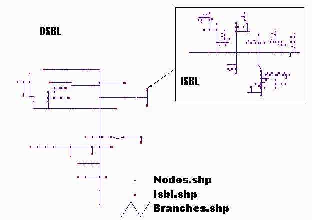
Several features comprise a sewer network: reaches, nodes, drops,
manholes, and drains. Liquid-to-air mass transfer occurs in the
reaches (also referred to as branches) and at drop structures.
Emissions occur at manholes, drains, and elevated vents by air
exchange.
naUTilus is a computer model written in FORTRAN which analyses
the data from an industrial sewer network and predicts the emissions
of volatile organic compounds (VOCs) from the network. It is the
product of a great deal of research done by several individuals
under the supervision of Dr. Richard Corsi
at the University of Texas at Austin.
naUTilus applies mass transfer principles to estimate liquid/gas
mass transfer in reaches and fluid mechanic and heat transfer
principles to calculate air exchange rates between the sewer network
and the ambient atmosphere. Several relationships used in naUTilus
were experimentally derived. The inputs to naUTilus are
the specifications of an industrial sewer network: flow rates,
concentrations, temperatures, and sewer characteristics. naUTilus
outputs the emissions and flow rates in that sewer network. The
two sections of a sewer network (OSBL and ISBL) are handled by
different sets of code in the naUTilus model
At present, a great deal of knowledge of the model is needed to
successfully run the naUTilus program. The input consists
of a text file; it is essentially a string of numbers representing
the system it is to model in a very specific format. To see an
example input file, click here. Similarly,
the output is a text file listing the output. To see an example
output file, click here. The example
files were for a sewer network consisting of 110 branches and
83 nodes.
The input file describes flow and concentration inputs to the
sewer network as well as the connectivity of the branches and
nodes. Information on the chemical of interest, pipe diameters
and slopes, drop heights and locations, opening size, temperature,
and wind speed are also a part of the input file.
To facilitate the use of naUTilus, a graphic user interface
(GUI) is desired. Input and output could then be directly associated
with a visual (schematic) of the sewer network . The user will be prompted for input and sewer characteristics will be more easily modified. Results would also be output in a visual, easy to interpret display.
The naUTilusArcView Interface
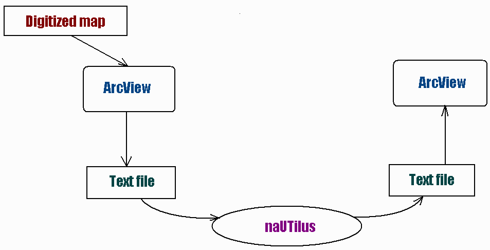
The naUTilus/ArcView interface is created using a series
of Avenue scripts. Avenue is an object oriented programming language
specific to ArcView. Through Avenue, the digitized map entered
to ArcView will be able manipulated to create the input file needed
by naUTilus. The model will also be executed from within
ArcView. In turn, ArcView will read the model output and, through
Avenue scripts, display the data in the desired visual format.
To define a term project of reasonable scope, the selected goal
was to enable ArcView to read and display naUTilus output
for an OSBL system.
The following steps were required to display naUTilus data
in ArcView.
- Creating a digitized schematic of a sample industrial sewer
network.
A paper map of an example sewer network was provided. Using AutoCad,
the schematic was digitized, using two layers: nodes and branches.
Each branch was drawn in the direction in which flow in that branch
occurs, as at later stages of the project, direction of flow in
a branch is important. Upon completion of the AutoCad drawing,
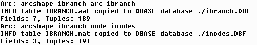
the digitized map was imported to Arc/Info, where the command
DXFARC was used to import the data into coverages.
For help in digitzing, see Exercise on Digitizing Coverages in AutoCAD and Arc/Info.
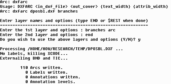
The above example shows DXFARC used on a file called "dposbl.dxf" to create a coverage called "branch". It uses the AutoCad layer "branches". This command was repeated for the layer "nodes", creating a coverage called "nodes".
After BUILDING the coverages, they were transformed into shape files and opened
as themes in ArcView. The themes are built on for user input and result display.
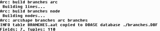
Note that the coverage "branch" was built in terms of both arcs and nodes. The "node" coverage need only be build for nodes.
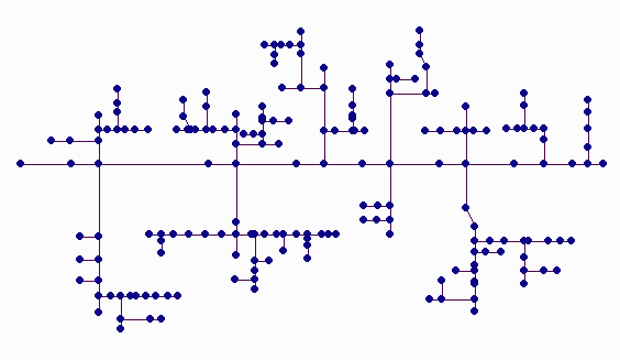
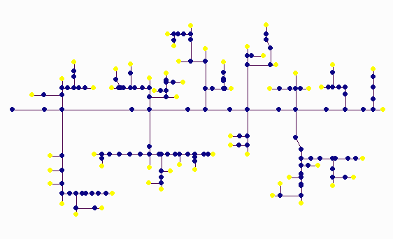
Each of the two AutoCad layers (nodes and branches) became a shape theme in ArcView. Each feature of the themes was labelled by its unique number. The unique number identifies each branch or node throughout the process of creating an input file, running naUTilus, and displaying the data.
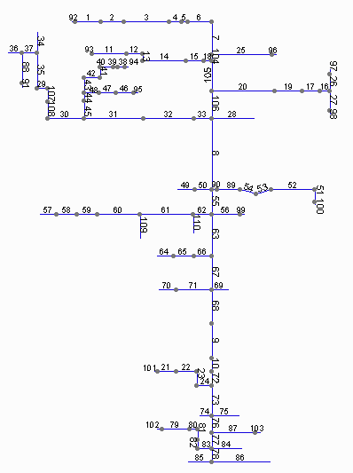
OSBL in ArcView, with branches numbered:
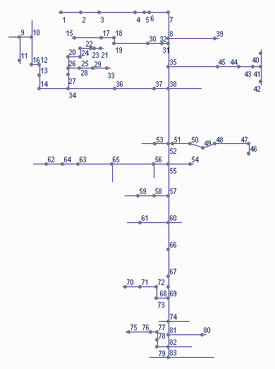
OSBL in ArcView, with nodes numbered:
 An issue when importing the schematic into ArcView was preserving
the branch/node connectivity. Importing both layers drawn in AutoCad
did not preserve the connectivity. At this stage in the project
it was not yet an issue, but a problem that would have to later
be resolved. A possible resolution is explored in a latter portion
of this report.
An issue when importing the schematic into ArcView was preserving
the branch/node connectivity. Importing both layers drawn in AutoCad
did not preserve the connectivity. At this stage in the project
it was not yet an issue, but a problem that would have to later
be resolved. A possible resolution is explored in a latter portion
of this report.
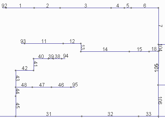
Another problem encountered in creating the digital map of the OSBL network was a discrepancy between naUTilus requirements and the sewer set up. naUTilus assumes flow enters the OSBL system at branches, while the schematic indicated that some inflow occurred at nodes. To solve this problem, a several short branches (1 meter in length) were added at the nodes where this occurred.
In the following graphic (a portion of the OSBL show above), nodes 92,92,94, and 95 are 1 meter branches added to the OSBL.
- Re-format naUTilus output.
Additional lines were added to the naUTilus code, writing
output to two comma separated variable text files, which could
be read directly into ArcView. One file was created for node data,
the first line consisting of titles for data fields. A similar
file was created for branch data.
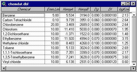
The comma separated text files consisted of an initial row, holding names used to define the columns of a table, and several rows of numerical data. As an example, see osblnd.txt.
- Run the naUTilus model.
This run was done through an input file manually generated. Once
the sewer network themes were opened in ArcView, the input file
was created using the node and branch numbers assigned by ArcView.
Once the input file was created, naUTilus was run from
the DOS prompt.
- Read data from naUTilus into Arcview.
This was done by writing a script which looked for the text files
output by naUTilus and joining that data to the attribute
tables. Joining the data was done with a script called JOINITEMS. Once JOINITEMS is run, the output from naUTilus is associated with the appropriate branch or node feature in ArcView.
- Display naUTilus output in ArcView.
Once the output from naUTilus was joined to the attribute tables in ArcView, a
script to manipulate the legend was created. The script DISPLAYEMM
offers two options for displaying emissions from each node. Both
options create 4 ranges of emissions values and display nodes
colored by the emissions range into which it's value falls.
Option one finds the maximum and minimum emissions which occur
and divide that range into four equal intervals. This option is
considered to display relative emissions ranges. Option two displays
emissions between set ranges. The final ranges to be used are
yet to be determined and will likely vary by chemical, possibly
depending on health effects.
Shown below is an OSBL unit: 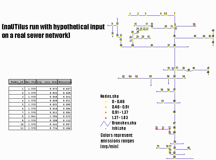
These results are shown on an actual industrial sewer network for the
chemical Benzene. Hypothetical inputs for flow, temperature, and
concentration values were used.
Other works in progress to enhance the naUTilus/ArcView
interface include:
Also, while the work done in this project was done on a schematic of an actual OSBL unit, that schematic was not to scale. The length of each branch had to be approximated and manually assigned. One goal is to get a to-scale map of a facility. Branch length could then be read directly from the digital file.
Several steps have yet to be completed for the OSBL portion of
the naUTilus code. Work is continuing on all steps.
- Enable input of sewer network specifications directly into
ArcView.
This is closely tied in to the development of the CREATETAB script.
- Format data from ArcView into appropriate format for input
to naUTilus.
This entails writing scripts which will write a naUTilus input file. Some changes to the present naUTilus code may be required.
- Run the naUTilus model and display data.
This run will be with input generated from ArcView.
Work similar to that done for OSBL is being done for ISBL, some
in parallel with steps yet to be completed for OSBL. In particular,
an input interface for both OSBL and ISBL is in the early stages
of development.
Some of the work completed for ISBL includes:
- Digitizing of schematic
A schematic (not to scale) of an actual ISBL unit was available
for digitizing. One issue with digitizing schematics is the unclear
notation used. An online drain was not indicated as a drain drawn
onto a branch, but as a short branch extending from the line into
which it feeds. Terminal nodes represented elbow drains. Manholes
or vents were indicated as nodes on branches.
- Import ISBL data to ArcView
Once the schematic was digitized in AutoCad, it was saved as a
DXF file. The DXF file was converted in Arc/Info, using the DXFARC
command. After BUILDING the arcs and nodes of the branch coverage,
it was converted into shape files to be opened in ArcView. An
issue in importing the data into ArcView is preserving the connectivity
of the system. A simple method to preserve the connectivity was
to create two shape files from the Branch coverage. One shapefile
was created to represent the branches, while a second shape file
was created of the nodes. This second shape file was used
as the nodes of the industrial sewer network.
This presented the new problem of dealing with the discrepancy
between ArcView's numbering method and the method used for naUTilus.
In ArcView, each branch is represented by two nodes: a "from
node" and a "to node". In this way, connectivity
of the branches is established. However, in naUTilus, only
nodes which are between two branches are numbered. Thus, the nodes
which initiate "start" branches are not numbered. To resolve
this numbering discrepancy, the script SORTPOINT
was written. After running SORTPOINT, all nodes which are not
numbered in the naUTilus numbering system are flagged.
Other nodes are then numbered. These numbered nodes will be used
to create the naUTilus input file.
ISBL unit showing flagged nodes:
These flagged nodes represent drains at which flow enters the system. The node on the far left is the terminal node in the system, where flow will be discharged to an OSBL system.
Several scripts were written to complete this project and have
been mentioned previously in this document. They are not in their
final format, as they will likely be modified before the entire
research project is complete. However, for the purpose of this
term project, they are functional. Each script must be run from
the script with the view as the immediately underlying document.
- JOINDATA
- DISPLAYEMM
- SORTPOINT
- CREATETAB
Eventually, these scripts will all be run from the button or tool bar in ArcView.
In addition to providing a user friendly interface, the integration
of naUTilus and ArcView allows for immediate "hot spot"
analysis and the possibility of fenceline risk assessment and
municipal sewer applications. "Hot spot" analysis consists of identification of problem areas where emissions may exceed tolerance levels. Fenceline risk assessment would consist of using dispersion models and naUTilus predictions to estimate contaminant levels at the boundaries of a plant. Being able to spatially orient the industrial sewer network would make fenceline risk assessment possible. Applying naUTilus to municipal sewers would further utilize the spatial capabilities of GIS. Emissions could be seen on a wide scale and in relation to other spatial data: streets, streams, land use, and various other data.
Data on some industrial sewer networks is being sought from Shell.
This data will include a network schematic, branch lengths, branch
diameters, drop structures, flow rates, concentrations, and temperatures.
Presently working on the naUTilus model is David Olson,
one of Dr. Corsi's
former students who now works for him as a Research Engineer.
On the GIS/ArcView side of this project, I am receiving help from
members of Dr. Maidment's
research group. Thanks to all who are contributing to this project!
I would also like to thank the Environmental Solutions Program (ESP) for funding this project.

To see the work that has continued and been completed since the completion of CE397K-Spring 1997, see the document Research Project Update.
Click here to return to my home page
Last edited: 4/23/97