Term Project
GIS Analysis of Census Data and Health Care Facilities in Cameron and Hidalgo Counties, Texas
by Michele Simpson
CE397 GIS in Water Resources
University of Texas at Austin
To Michele Simpson's Home Page
The Texas-Mexico border is a region of concern for the Texas Department of Health (TDH). Given the high rates of poverty in this area, public health dynamics along the border are complicated. Specific issues along the border include (but are not limited to) environmental health, maternal and child health, prenatal care, family planning, and immunizations (Hatcher, 1995). In particular, two counties along the border have experienced high incidences of Neural Tube Defects (NTDs), birth defects that are serious and often fatal, and are the focus of a TDH study. NTD rates in Cameron and Hidalgo counties are as high as three times the national average. The TDH NTD surveillance intervention project hopes to reduce the number of pregnancies affected by NTDs. The TDH plans to use Geographic Information Systems (GIS) in this investigation. Kris Martinez is currently working with the TDH to implement this component of the investigation. The objectives of this term project are to contribute to this study by:
Cameron and Hidalgo Counties in Texas (click image for larger scale)
ArcView3.0 was used to geocode the facilities. Carolyn Nobel has written a Geocoding Exercise as her term project which explains how to geocode in ArcView. The exercise focuses on Brownsville, which is in Cameron county.
The following procedure was used to geocode the primary care facilities and the maternity facilities in Cameron and Hidalgo counties.
Five out of 23 maternity facilities and 13 out of 37 primary care facilities were not matched. Potential reasons for this include: 1) addresses which are not street addresses could not be located (i.e., addresses with Rt. and Box number), 2) the street database may not include the streets that the facilities are located on, and 3) the addresses given may be incorrect. The facilities which were not matched were forwarded to the TDH for clarification. After the addresses had been checked by the TDH, ArcView was used again to geocode them. Unfortunately, the addresses were still not matched by ArcView, even with the sensitivities relaxed in Interactive Re-Match. Thus, the following facilities are not geocoded:
|
Primary Care Facilities |
. | . | . | . |
| Brownsville Community Health Center | 2137 E. 22nd Street | Brownsville | Cameron | 78521 |
| Brownsville Community Health Center Satellite Clinic | 2100 Avenida Gregory | Brownsville | Cameron | 78521 |
| Heart Clinic Inc. | 1330 E. Sixth West | Weslaco | Hidalgo | 78596 |
| Heart Clinic Inc. | 954 W. Price Rd. | Brownsville | Cameron | 78596 |
| Los Fresnos Family Medical Clinic | 725 Ocean Blvd Hwy 100 | Los Fresnos | Cameron | 78566 |
| McAllen Medical Center | 301 W. Expressway 83 | McAllen | Hidalgo | 78503 |
| Mercedes Health Clinic | 330 N. Ohio | Mercedes | Hidalgo | 78570 |
| Port Isabel Satellite Clinics | 705 S. Longoria St. | Port Isabel | Cameron | 78578 |
| Rio Hondo Health Clinic | Hwy 106 Rt. 1 Box 211 | Rio Hondo | Cameron | 78583 |
| Su Clinica Familiar Raymondville Clinic | 131 FM 3168 | Raymondville | Cameron | 78580 |
| Su Clinica Familiar Family Health Services Program | 4000 FM 511 | Brownsville | Cameron | 78521 |
| Valley Procare Clinic | E. 77 Sunshine Strip | San Benito | Cameron | 78586 |
| Valley Regional Island Clinic | 3000 Padre Blvd | Port Isabel | Cameron | 78578 |
|
Maternity Facilities |
. | . | . | . |
| Nueva Esperanza Maternity Clinic | 8004 S. Cage Blvd | Pharr | Hidalgo | 78577 |
| Vicky's Birthing Center | 1 Royal Palm | Brownsville | Cameron | 78520 |
| Holy Family Birthing Center | Rt. 1 Box 257 | Weslaco | Hidalgo | 78596 |
| Knapp Medical Center | 1401 E. 8th St. | Weslaco | Hidalgo | 78559 |
| McAllen Medical Center | 301 W. Expressway 83 | McAllen | Hidalgo | 78503 |
In addition to geocoding by street address, ArcView can also geocode by latitude and longitude. Therefore, once the latitude and longitude for these facilities is known, they can be geocoded.
The following figures depict the location of primary care facilities and maternity facilities in Cameron and Hidalgo counties.
 Primary
Care Facilities in Hidalgo County
Primary
Care Facilities in Hidalgo County
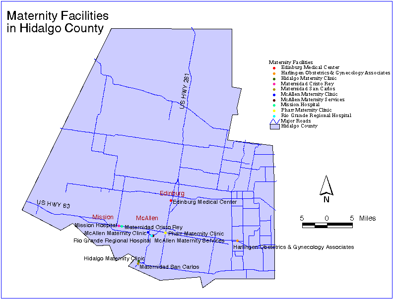 Maternity
Facilities in Hidalgo County
Maternity
Facilities in Hidalgo County
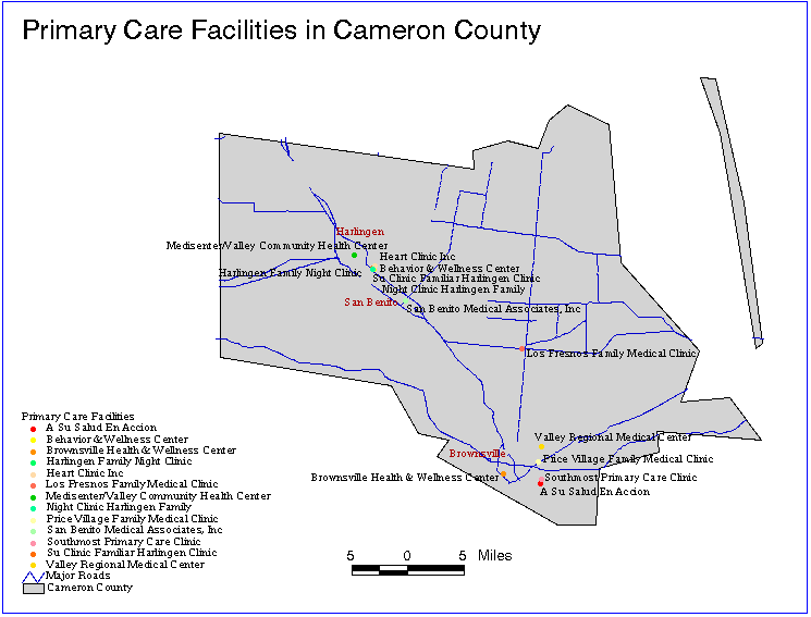 Primary
Care Facilities in Cameron County
Primary
Care Facilities in Cameron County
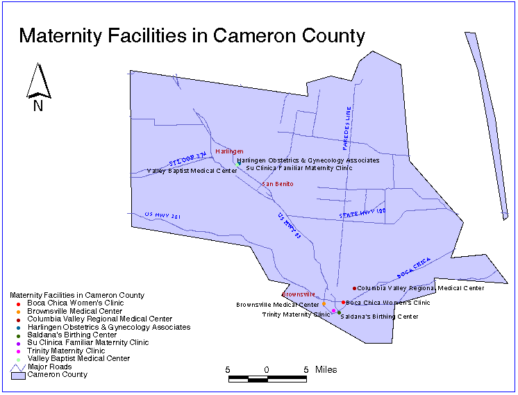 Maternity
Facilities in Cameron County
Maternity
Facilities in Cameron County
To achieve the highest resolution of census data, two sources of data had to be joined. Tiger data consists of census data at the tract level, while Census data gives information at the block level. An average of five blocks make up one tract, therefore data at the block level is more detailed geographically. Census data is given as a database file containing demographic data, but no geographic data, while Tiger data does include geographic data. Therefore, the census information had to be joined to the Tiger data in order to display census data at the block level. A unique field, identical in Tiger and Census, had to be created to make this join possible.
Both the Tiger data and the census data were acquired from TNRIS. The TNRIS ftp site includes the txcensus.dbf table (Census information) in the support directory and Tiger files in the tx directory. The following steps are necessary to get the desired files from the TNRIS ftp site:
Another option for obtaining census data is Ceisin census data, which includes census data for the entire United States.
To display census data at the block level, a unique field, identical in Tiger and Census, had to be created so that the two could be joined; the Tiger coverage had to be dissolved and then projected in the same projection as the geocoded facilities; and the two tables had to be joined in ArcView. The following steps summarize the data manipulation.
2. Create the unique field in Census
The field BLCKGR-ID in Tiger was chosen as the unique field. BLCKGR-ID is a concatenation of the fields CNTY, CTBNA, and BLK (the value in the first column of BLK) in Tiger. This field was chosen because it could be created in the census table by combining the fields CNTY, TRACTBNA, and BLCKGR in census. First, the way in which Tiger joined the fields to create BLCKGR-ID had to be determined. For instance, CNTY, CTBNA, and BLK are 3, 6, and 4 characters long, respectively. However, CTBNA often consists of only 4 characters. Since BLCKGR-ID consists of 10 characters, the first three characters being the county fips code (CNTY) and the last character being the first digit of BLK, it was determined that when CTBNA is less than six characters, zeros are added to the beginning of the field so that it is 6 characters long. In Census, however, zeroes had to be appended to the end of TRACTBNA, when the field was less than 6 characters, before using it in the creation of BLCKGR-ID. Further discussion on the changes made to Census and Tiger follows.
2. Create the unique field in Census
First, the census database ("txcensus") was changed to an info file using the DBASEINFO command, and then data for cameron (fips code = 061) and hidalgo (fips code = 215) counties was selected out of the database and renamed "chcensus" using the following commands:
Enter Command: select txcensus <selects the txcensus table>
Enter Command: reselect for cnty ne '061' and cnty ne '215' <selects all records where the field cnty is not 061 (Cameron) or 215 (Hidalgo)>
Enter Command: purge <deletes all records selected, therefore only records for Cameron and Hidalgo counties remain>
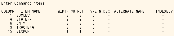
The unique field, BLCKGR-ID, is the concatenation of the fields CNTY, TRACTBNA, and BLCKGR in chcensus. The items command in Tables in ARCINFO lists the attributes in the table of interest.
BLCKGR-ID must be 10 characters wide (WIDTH) and of type 'C' (TYPE) to exactly match Tiger. As the table above shows, the column addition of CNTY, BLCKGR, and TRACTBNA is 10 columns. The command list, which lists actual table values, shows that both CNTY and BLCKGR are always filled with three and one character(s), respectively, however TRACTBNA occassionally only contains four characters. Therefore the remaining two empty spaces must be filled with zeroes so that when TRACTBNA is used in the concatenation to form BLCKGR-ID, BLCKGR-ID will be 10 characters wide and will correspond to BLCKGR-ID in Tiger. Columns 13 and 14 are potential locations of blank spaces in TRACTBNA. To replace these blanks with zeroes, the redefine command was used to redefine the columns, so that they could be referenced in reselect and move, which selects the columns with blanks and moves zeroes into their place, respectively. The commands used to accomplish this in Tables in ARCINFO are shown below:
Enter Command: redefine <indicates the creation of a new item from existing ones>
Enter starting column: 13 <begins the new item at column 13 of the chcensus table, the fifth column of the TRACTBNA field>
Item name: s13 <a temporary name>
Item width: 1 <takes just the fifth column TRACTBNA>
Item output width: 1 <display width>
Item type: c <character display>
Enter starting column: 14 <begins the new item at column 14 of the chcensus table, the sixth column of the TRACTBNA field>
Item name: s14 <a temporary name>
Item width: 1 <takes just the sixth column TRACTBNA>
Item output width: 1 <display width>
Item type: c <character display>
Enter starting column: <carriage return to exit this dialogue>
Enter Command: reselect for s13 = ' ' <selects all records in the new item s13 that are blank>
Enter Command: move '0' to s13 <moves zeroes to all blank records found in s13>
Enter Command: aselect <unselects s13, all records now present>
Enter Command: reselect for s14 = ' ' <selects all records in the new item s14 that are blank>
Enter Command: move '0' to s14 <moves zeroes to all blank records found in s14>
Enter Command: aselect <unselects s14, all records now present>
Now all records in TRACTBNA should contain 6 characters and the unique field can be created. Redefine creates a new item from existing ones. The table above shows that the redefined item needs to begin at column 6 and go through column 15 (10 columns wide) to include CNTY, TRACTBNA, and BLCKGR. The following commands were used to redefine a new temporary item (ID), add an item to the chcensus table (BLCKGR-ID), and move the temporary item to the new item in chcensus.
Enter Command: redefine <indicates the creation of a new item from existing ones>
Enter starting column: 6 <begins the new item at column 6 of the chcensus table, the beginning of the CNTY field>
Item name: id <a temporary name>
Item width: 10 <takes the 3 characters of CNTY, 6 of TRACTBNA, and 1 of BLCKGR treated as character text>
Item output width: 10 <display width>
Item type: c <character display>
Enter starting column: <carriage return to end dialogue>
Enter Command: sel <closes chcensus>
Enter Command: additem chcensus blckgr-id 10 10 c <adds a new item to the chcensus table called blckgr-id, located at the end of the table>
Enter Command: sel chcensus <select chcensus table again>
Enter Command: move id to blckgr-id <puts values defined earlier in the temporary item id into the new item blckgr-id>
BLCKGR-ID in the Tiger files contains only 9 characters when CNTY (the county fips code) is only two digits. Since CNTY in chcensus appends a zero to the front of the field when it is only 2 characters (i.e., Cameron fips code = 61), zeroes had to be added to the beginning of BLCKGR-ID in the Tiger data (when CNTY is only two digits) so that the BLCKGR-ID field in chcensus and the BLCKGR-ID field in the Tiger files were identical. Recall that in creating BLCKGR-ID in chcensus, zeroes were appended to TRACTBNA. Similarly, zeroes were added to the beginning of BLCKGR-ID in the Tiger files using the following commands.
Enter Command: redefine <indicates the creation of a new item from existing ones>
Enter starting column: 86 <begins the new item at column 86 of the table, the beginning of the BLCKGR-ID field>
Item name: s86 <a temporary name>
Item width: 1 <takes the first character of the BLCKGR-ID field>
Item output width: 1 <display width>
Item type: c <character display>
Enter starting column: <carriage return to exit this dialogue>
Enter Command: reselect for s86 = ' ' <selects all records in the new item s86 that are blank>
Enter Command: move '0' to s86 <moves zeroes to all blank records found in s86>
Enter Command: aselect <unselects s86, all records now present>
The Tiger data was dissolved by the unique identifier to create a coverage which was the county by BLCKGR-ID. The field that the coverage is being dissolved by must be a character type. This can be checked using the items command and changed using the alter command. The following command was used to dissolve the hidalgo county coverage by BLCKGR-ID:
Arc: dissolve hidalgo hidadis BLCKGR-ID <dissolves the hidalgo coverage by BLCKGR-ID, and creates the hidadis coverage>
The coverages had to be projected into the same projection used for the geocoding so that they could be opened together in ArcView. Therefore, the projection had to be changed from lambert to geographic. The following input file is called "geo.apr" and was used in the command: Arc: project cover camdis camgeo geo.apr
input
projection lambert
units meters
datum GRS1980
parameters
27 25 0.000
34 55 0.000
-100 0 0.00
31 10 0.000
1000000.00000
1000000.00000
output
projection geographic
units dd
datum NAD83
parameters
end
The polygon and polygon attribute table were built, after the projection was changed, using the command:
Arc: build camgeo poly
The census data was joined to the Tiger data in ArcView using the following steps.
These steps were repeated for Hidalgo county, thus a shape file exists for each county which includes demographic data at the block level.
One specific request the TDH had for this project was layouts including demographic data for women of reproductive age and the location of maternity facilities. Unfortunately, the census information did not include gender data. The Rural Public Health web page includes Databases which include Prepared Maps of census data for Texas. These maps were created in conjunction with Texas A&M at the Blackland Research Center (BRC) and include demographic data on the female population (1990) and the white female population (1990). The BRC ftp'ed the files containing the data used to create these figures to me. Unfortunately, the ftp'ed data was not in a format that I could use to link with my tables.
The following figures show the difference between census data at the tract level (just using the Tiger files) and census data at the block level (Census data joined with Tiger data). As the figures indicate, displaying census data at the block level provides much higher resolution.
 Comparison
of Census Data at the Tract and Block Level, Cameron County
Comparison
of Census Data at the Tract and Block Level, Cameron County
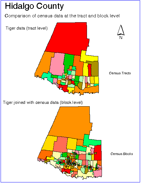 Comparison
of Census Data at the Tract and Block Level, Hidalgo County
Comparison
of Census Data at the Tract and Block Level, Hidalgo County
The procedure described in this report results in census coverages at the block level and geocoded health facilities for Cameron and Hidalgo counties. Using these together, useful maps can be created which provide a decision-making tool for the TDH. Graphical representation of census information, along with the located facilities, can assist the TDH in better understanding its patients and optimizing the location of any new facilities. The following figures are examples of layouts that can be created using the census data and the located facilities together.
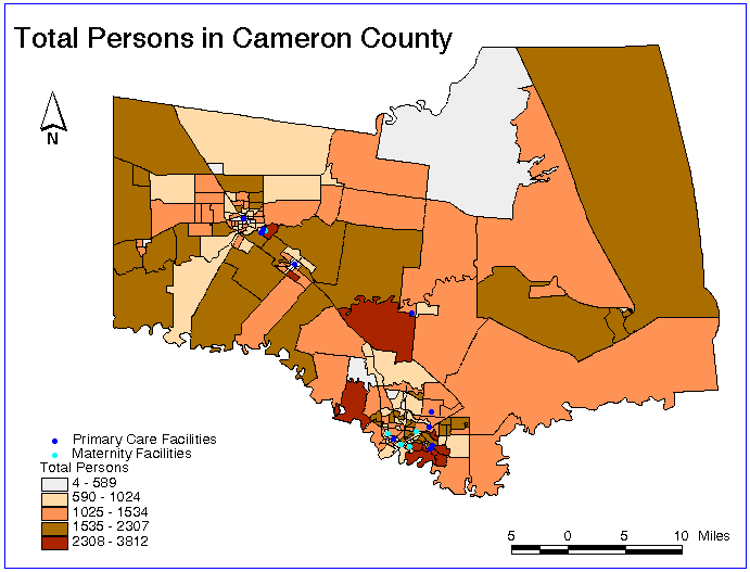 Total
Persons in Cameron County (primary care and maternity facilities
included)
Total
Persons in Cameron County (primary care and maternity facilities
included)
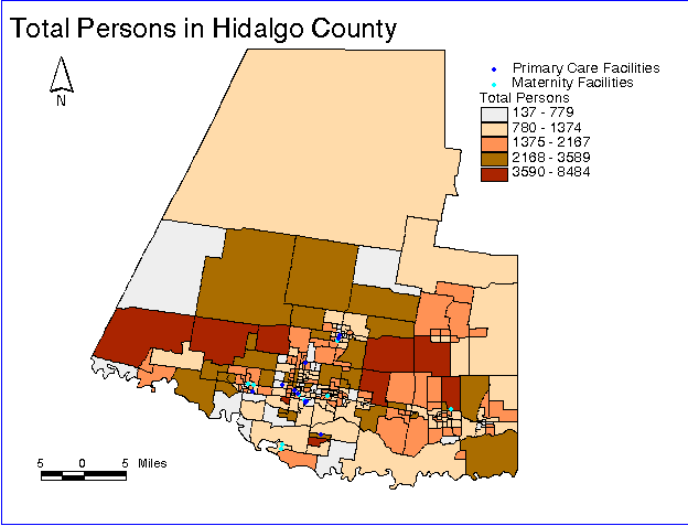 Total
Persons in Cameron County (primary care and maternity facilities
included)
Total
Persons in Cameron County (primary care and maternity facilities
included)
 Percent
Children (0-4 years old) in Cameron County (primary care
facilities included)
Percent
Children (0-4 years old) in Cameron County (primary care
facilities included)
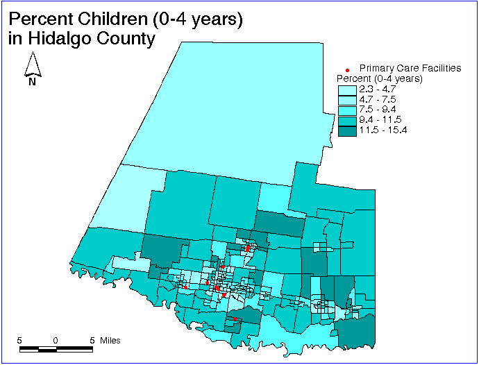 Percent
Children (0-4 years old) in Hidalgo County (primary care
facilities included)
Percent
Children (0-4 years old) in Hidalgo County (primary care
facilities included)
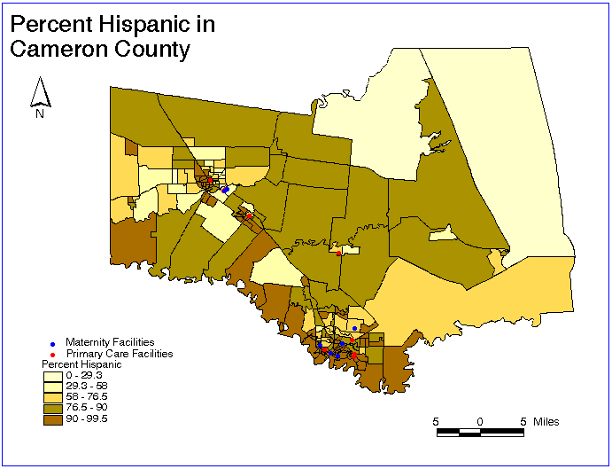 Percent
Hispanic Population in Cameron County (primary care and maternity
facilities included)
Percent
Hispanic Population in Cameron County (primary care and maternity
facilities included)
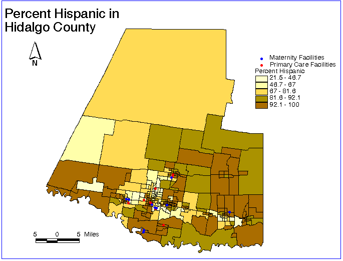 Percent
Hispanic Population in Hidalgo County (primary care and maternity
facilities included)
Percent
Hispanic Population in Hidalgo County (primary care and maternity
facilities included)
When used in ArcView, the two county coverages and the located facilities, along with their attribute tables, allow the user to obtain useful, detailed information on each facility and each block of census data. For Cameron county, for instance, if the Cam, Primary Care theme is highlighted in the view and the Attributes of Cameron Primary Care Fac. table is open, the user can click on a particular facility in the view and the corresponding record in the Attributes of Cameron Primary Care Fac. table will be highlighted, giving the facility name and address. Likewise, if the Cam, Census theme is highlighted in the view and the Attributes of Cameron Census Data table is open, the user can click on a particular block in the view and the corresponding record in the Attributes of Cameron Census Data table will be highlighted, giving all of the census data for that block (i.e., population by age, ethnicity, etc.). Also, once the user has located the particular facility (as described above) or region of interest, the view can be zoomed in for greater detail. The following figures show the ArcView screen when these applications are performed.
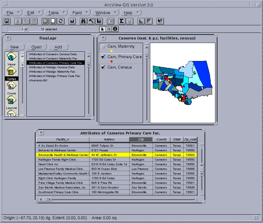 Obtaining
detailed information on a particular facility
Obtaining
detailed information on a particular facility
(note, the chosen facility is highlighted in the view and the corresponding record is highlighted in the attributes table)
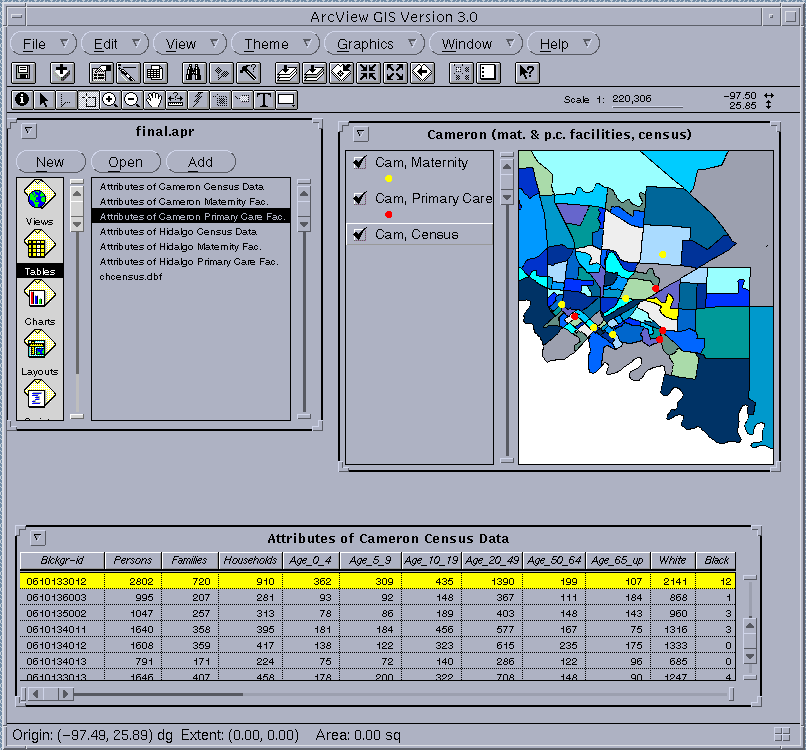 Zooming
in on a region of interest and obtaining detailed census information on
a particular block
Zooming
in on a region of interest and obtaining detailed census information on
a particular block
(note, the chosen block is highlighted in the view and the corresponding record is highlighted in the attributes table)
Additionally, there is a feature in ArcView within the Theme menu that allows the user to select features of a theme (i.e., census data) that are within a specified distance of a selected feature (i.e., a particular facility). To apply this in Cameron county for instance, the user would:
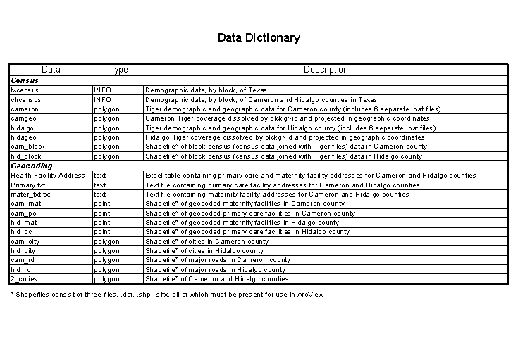
The following table indicates the names of the Views, Themes (and associated shape files), and Tables in the ArcView project final.apr, which is the final ArcView application including census data at the block level and geocoded primary care facilities and maternity facilities.
| Item in final.apr | Cameron County | Hidalgo County |
| Views | Cameron (mat. & p.c. facilities, census) | Hidalgo (mat. & p.c. facilities, census) |
| Themes | . | . |
|
Census |
Cam, census | Hid, census |
|
(source) |
cam_block.shp (Polygon) | hid_block.shp (Polygon) |
|
Maternity Facilities |
Cam, Maternity | Hid, Maternity |
|
(source) |
cam_mat.shp (Point) | hid_mat.shp (Point) |
|
Primary Care Facilities |
Cam, Primary Care | Hid, Primary Care |
|
(source) |
cam_pc.shp (Point) | hid_pc.shp (Point) |
| Attribute Tables | . | . |
|
Census |
Attributes of Cameron Census Data | Attributes of Hidalgo Census Data |
|
Maternity Facilities |
Attributes of Cameron Maternity Fac. | Attributes of Hidalgo Maternity Fac. |
|
Primary Care Facilities |
Attributes of Cameron Primary Care Fac. | Attributes of Hidalgo Primary Care Fac. |
I was fortunate to have assistance from several people on this project, including:
Thank you for your contribution to this project!
Hatcher, Jeanette, Jillian Hopewell, Adriana Guardiola, Kathy Jacquart, Walter Moreau, Jeff Stys, Louis DeNino, and David Warner, The Border Health authority: Issues and Design, U.S.-Mexican Occasional paper No. 6, U.S.-Mexican Policy Studies Program, Lyndon B. Johnson School of Public Affairs, the University of Texas at Austin, February 1995.