Data sourcesData sources
![]()
A suitable street map must be bought before pins can be pushed into it to represent locations. Similarly, before starting geocoding, a suitable data set must be acquired and formatted.
Most street data sources are derived from TIGER/Line files.(Click here for TIGER/Line file user's guide) TIGER/Line files contain information that describes the points, lines, and areas on Census Bureau maps. These files provide information on streets, rivers, railroads, and other line features, as well as where they intersect and the areas they enclose, in a form that can be processed by a computer. While these file contain geographic data, they are not maps or geographic information systems by themselves. Users must first import or reformat the data into an application system or software.
Several possible sources were researched for obtaining the formatted street data.
Business Location Research (BLR) Street Network 6.0 and ETAK EtakMap were both researched as possible alternatives. These products contained streets in several layers and other landscape features such as airports and water features which would result in aesthetically pleasing maps. However, neither was specifically formatted for ArcView and they both cost ~$1000 for the Brownsville-Mcallen, area (one Metropolitan Statistical Area (MSA)).
Around March, (good timing!) ESRI announced the introduction of a low-cost nationwide street database. This street database consists of five gigabytes of U.S. street data (no other attributes are included) comprised into 102 shapefiles on four CD-ROMS. The 102 shapefiles include one for each of the 50 largest MSAs and one for the rest of the streets in each state (except for Texas, which is split into east, central and west segments.) The street data for the entire US cost ~$500 and was developed specifically for use with ArcView.
Due to cost and software application considerations, the ESRI Street database was selected for use in this project. U.S. Streets contains interstate, U.S. and state highways, other major thoroughfares and all local streets within the United States. This data later is advertised to overlay accurately on other boundary data, although it did not match exactly with the county files' boundaries. The nationwide street database is based on the Geographic Data Technology (GDT) Dynamap/1000 street file, an improved version of census TIGER data.The addresses for the Brownsville industries were taken from the Brownsville Chamber of Commerce Manufacturing Directory and entered into an Excel file. The excel file was imported into ArcView as a Table. (Note: the file needed to be saved as a .txt file to ensure the data did not get truncated). Those industries used for the exercise were chosen for their ease in geocoding.
The latitude and longitude data used in the exercise was acquired from the EPA SPLAT (Spatial Preferred Locational Attribute Table) database. The information from this table includes the names of industries, their latitude and longitude, address and accuracy information. SPLAT is a local database for now, but eventually the data will be added to the Locational Reference Tables in Envirofacts, a user-friendly relational database that integrates data extracted from EPA program systems. (See the Producing a Map On Demand section of the exercise for more information.)
Streets represent just one attribute of the Brownsville area. When building up a basemap, it may be necessary to include other features such as elevation, water attributes or census data. A wide variety of this information is available through links from Dr. Maidment's Homepage from the CE397 Course Outline
OTHER BASEMAP LINKS
Texas Natural Resources Information System: Texas digital environmental data
TNRCC Geographic Information Systems : TNRCC available spatial data
Raster Data: (from TNRCC link)
EPA Envirofacts: "Maps on Demand" of the Brownsville area including a listing of regulated facilities with their Latitude/Longitude
Data Dictionary
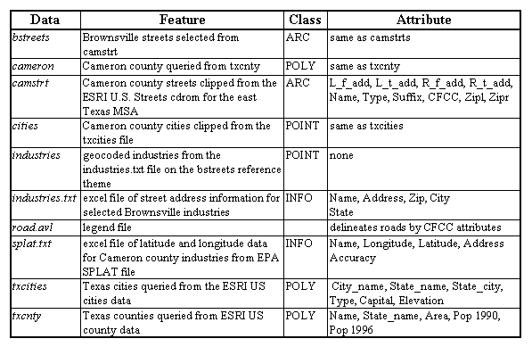
The data dictionary contains a description of all the files used and generated in the Geocoding exericise, including feature, class and attribute information.