


CE 397 GIS in Water Resources
University of Texas at Austin
The objectives of this term project are to:
Information sources include:
Expected results include:
The field of wetlands research in the United States has dramatically expanded in the past decade. The general concept of wetlands as swamps that needed to be filled in or drained for useful land activities such as agriculture flourished until the 1980's. The federal policies of this country encouraged and even subsidized the destruction of wetlands and as a result the total wetlands acreage has been reduced by 50% in the US. Concerns for the losses of the valuable benefits from wetlands such as critical wildlife habitat, flood control, and water quality enhancement, gained political support in the 1970's and now protective regulations exist for all public and private wetlands in the US.
The official regulatory reference definition of wetlands shows that three major factors are used to characterize a wetland - water, soil, and biota. A wetland is an ecosystem that depends on constant or recurrent, shallow inundation or saturation at or near the surface of the substrate. The minimum essential characteristics of a wetland are recurrent, sustained inundation or saturation at or near the surface and the presence of physical, chemical, and biological features reflective of recurrent, sustained inundation or saturation. Common diagnostic features of wetlands are hydric soils and hydrophytic vegetation. These features will be present except where specific physiochemical, biotic, or anthropogenic factors have removed them or prevented their development. (1)
There is still much scientific work to be done to determine the relationships between hydrology, soils, and vegetation, and the existence and functions of wetlands. One of the major efforts underway in the identification, delineation, and cataloging of all of the wetlands present across the country is the National Wetlands Inventory (NWI) Program. The NWI was begun by the US Fish and Wildlife Service (FWS) in the mid-1970's for resource assessment of the nations wetlands. Maps are prepared by stereoscopic interpretation of aerial photographs. Boundaries are drawn directly on the photo transparencies with a 0000 drafting pen and they must have time-intensive field verification for quality control. Finally, the wetland boundaries are transferred from the photographs to 1:24,000 maps. Before 1980, 1:80,000 (1cm=800m) black and white panchromatic photos from the USGS were used. From 1980 to 1992, higher resolution 1:58,000 color infrared photos were obtained from the National High Altitude Photography program. In 1992 the resolution was again improved using 1:40,000 color infrared aerial photography from the National Aerial Photography Program. This presents an obvious source of wetlands underestimation. Identification is limited to the date the photos were taken, which are not specifically timed for optimum wetlands conditions in that area. Also current inventories are inaccurate because some of the photos were taken over 20 years ago. Other sources of inaccuracies include the type of wetland being mapped. Areas that have distinctly changing terrain show clear boundaries, while level terrain such as coastal regions do not have easily distinguishable boundaries. Forested wetlands are obscured by vegetation and farmed wetlands are not included in the NWI surveys. These limitations make it clear that NWI mapping should not be used as a comprehensive inventory, but are still very useful as a broader interpretation. Delineation by actual field surveys during optimum wetlands conditions should be used when higher degrees of accuracy are needed.(1)
NWI maps are digitized in a format that is compatible with the computerized Geographic Information Systems (GIS), which display and analyze spatially distributed data and their associated tabular attribute information. As the digitized wetlands database expands, the capabilities of the GIS system will enhance the study, management, and regulation of wetlands.
This report will focus on documenting the processes of acquiring and utilizing digitized wetlands data from the National Wetlands Inventory Program.
Hard copy mylar maps of wetlands are available from NWI for a large percentage of the country, including most of Texas. However, digitized versions of the maps are available for only a small percentage of locations. The digitizing process is very labor- and time-intensive, so the regions that have been completed are usually from areas where active research is occurring.
NWI status map, April 1997

As with many of the processes involved in acquiring data from the NWI, determining what sites are available within the state of Texas is not straight forward. The home page of the NWI internet site has a hook for Status and this page has a hook titled search our metadata index for finding specific sites available. This method was designed for those who are familiar with the USGS 1:100K region name and the USGS quad abbreviation for the individual site name within the region. The search index cannot do general searches for sites within a state. To obtain a complete listing of all digitized sites located in Texas, I sent an e-mail to the NWI help address through the browser site http://www.nwi.fws.gov/comments_form.html. Their direct e-mail address can also be used: ops@nwi.fws.gov. They sent, via e-mail, a complete list of digitized maps for the state of Texas.
Digitized Wetlands Maps for Texas (February 1997 listings)
There are 14 regions and 234 individual sites currently available for the state of Texas. Using a state map I determined which regions were in the watershed for Corpus Christi: 33 sites within the corpus christi region directory and 60 sites within the beeville region directory.
The NWI home page contains a hook titled Data which gives a listing of the types of data available to download including:
The hook titled download data takes you to the NWI Internet ftp site. ReadMe files exist at every level of the ftp hierarchy that are very helpful although important process information is absent from several of them. It is recommended to download these files ,as well, for convenient referencing. One critical piece of information that was not readily available was the name of the NWI ftp site to access from the workstation terminal.
Once the compressed files are transferred to the workstation, they must be unzipped and untarred from the terminal prompt (filename.tgz = filename.dlg + filename.att):
danube{/home/hinojos/nwimaps/baycity}% ls
Makefile
README
parse.c
parse.tar
parse.txt
parse*
dlgconvert.aml
dlg2arc.aml
dlglaunch.aml
dlgbuild.aml
dlgmajor.aml
dlg2arc.menu
baycty.tgz ( individual site compressed file contains .dlg and
.att files)
byc.txt (contains list of all site names for the region -
abbreviation and full length )
danube{/home/hinojos/nwimaps/baycity}% gunzip baycty.tgz
danube{/home/hinojos/nwimaps/baycity}% tar xvf baycty.tar
x baycty.att, 2640 bytes, 6 tape blocks
x baycty.dlg, 842960 bytes, 1647 tape blocks
danube{/home/hinojos/nwimaps/baycity}%
NWI provides software to convert .dlg files to Arc/Info coverages and .att files to parsed attribute .atp files,. which must also be uncompressed after transferring them to the workstation. These are located in the software/aml directory and the software/parse directory, respectively. They must be copied into each region directory to execute the conversions.
To successfully execute the conversion programs, all Unix directory names must be lower case for Arc/Info recognition.
danube{/home/hinojos/nwimaps/baycity}% parse baycty.att
danube{/home/hinojos/nwimaps/baycity}% ls *.dlg | sed 's/.dlg//'
> convertlist
danube{/home/hinojos/nwimaps/baycity}% arc
Arc: &r_dlg2arc.txt
To convert DLG3 optional files to ARC/INFO coverages using this AML,
you must first have an input file named convertlist in this directory
which contains the DLG3 filename abbreviations in single column form.
If an intersection error is encountered during this AML, fix
the coverage in ARCEDIT. Then remove the DLG3 filenames for all but the
updated coverages from CONVERTLIST and run DLGBUILD.AML on remaining
coverages to build topology.
HELP is available by viewing the README file that accompanies this program.
AML selection menu:
1 - DLGCONVERT.AML (Converts DLG3 files to ARC/INFO and builds topology)
2 - DLGBUILD.AML (Builds topology after intersection errors have been fixed)
3 - EXIT (Exits AML)
1
Do you wish to use the .atp files in processing (y/n)? y
PROCESSING baycty.dlg
Converting Category from Map Bay_City,TX.
Scale is 24000, Resolution is 0.610.
YOUR DLG2ARC CONVERSIONS ARE COMPLETE...
Arc:
Questionable attributes: 0
Records processed: 32
danube{/home/hinojos/nwimaps/baycity}%
The dlg.errors file contains a complete record of the conversion steps. The Questionable attributes line listed above will record a zero if no problems occurred in the conversion. If problems do occur, follow the help steps for correcting the errors. If this fails, e-mail the file to the NWI help site.
The Arc/Info coverages take up a large amount of memory, so it is advisable to remove all *.tar, *.dlg, and *.att files after confirming that all coverages are correct.
When the conversion is complete, each individual site will consist of two ArcInfo coverages (a polygon coverage for the USGS quad, *.wic, and a point coverage of the wetland sites, *.wip) with an attribute table associated them.
Here is what an individual site looks like (rockpt.wic and rockpt.wip):
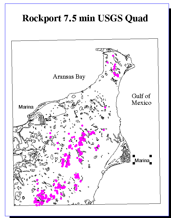
The NWI coverages are in the Universal Transverse Mercator (UTM) projection. The coverages, which were obtained from various directories within the University of Texas' Center for Research in Water Resources (CRWR) database, are in the Texas State Mapping System (TSMS) albers projection. These data can also be obtained from the USGS internet site . These were converted to the UTM projection for compatibility with the NWI coverages. Below is the aml projection file, albutm.prj, used for the conversion:
input
projection albers
units meters
datum nad83
parameters
27 25 00
34 55 00
-100 00 00
31 10 00
1000000.0
1000000.0
output
projection utm
units meters
datum nad83
zone 14
parameters
end
One of files used is an ArcView Shapefile that must first be transformed into an ArcInfo coverage. At the ArcInfo prompt type:
Arc: shapearc texas tex
Arc: clean tex tex1 # # poly
Cleaning /HOME2/HINOJOS/TEX
Sorting....
Intersecting....
Assembling polygons....
Re-building AAT....
Arc: build tex2 poly
Building polygons....
Re-building AAT....
To convert each coverage to UTM, at the Arc prompt type:
Arc:project cover tex2 tex3 albutm.prj
Arc: clean tex3 texutm # # poly
Cleaning /HOME2/HINOJOS/TEX3
Sorting....
Intersecting....
Assembling polygons....
Re-building AAT....
The coverage texutm has been created and converted to UTM projection. This coverage displays the state of Texas and all of the counties within the state.
The coverage of the counties in Texas was originally obtained as a Shapefile (texas.*) from a database established at the Center for Research in Water Resources (CRWR). The data files are found at ftp.crwr.utexas.edu in the directory /pub/gisclass/ex1/.
The file named mapcode.txt is a text file which provides explanations of the map codes used as wetlands attributes in the NWI digital data files. This is the same information shown in the legend of hardcopy NWI wetlands maps. The file is located within the NWI home page, data hook, download data hook, maps directory.
The file named wetlands.atts is a text file that lists all of the attributes found so far in NWI digital wetlands data files. The file is located within the NWI home page, data hook, download data hook, maps directory.
The file named wetcodes.exe is a DOS executable file for PC's or MacIntosh computers. The file is located within the NWI home page, data hook, download data hook, maps directory.
Transfer these files via ftp from the PC DOS Command Prompt into the desired working directory. For the university's LRC PC's, the files must 1st be transferred into the common use incoming directory, then ftp to the desired working directory.
Once the executable file has been downloaded, run the wetcodes.exe from the DOS Command Prompt to extract the 5 working files. The ReadMe file explains the uses of the 5 working files. From the windows environment, the atx.exe program can be run to obtain the full name of the map code abbreviations. The program will prompt you to enter an NWI map code (e.g., PUBHh). The program will then return a full explanation of the code (e.g., Palustrine, Unconsolidated Bottom, Permanently flooded, Diked/impounded). A more indepth explanation of what each of these terms means can then be obtained from the NWIDEFS.DAT definition data files.
The NWI classification hierarchy is based on wetlands hydrology, substrates, and vegetation:
System
SubSystem
Class
SubClass
The initial defining category, System, is composed of hydrogeomorphic wetland classes which are based on geomorphic setting, water source, and hydrodynamics. (Riverine, Palustrine, Estuarine, ...)
Next in the hierarchy is Subsystem, which is a measure of the length of time that the wetland is inundated with water. (Perennial, Intermittent, Tidal, ...)
Class is the third subcategory in the classification system which is related to the substrate present in the wetland. If there is no vegetation present, it is simply gives the substrate present. When vegetation does occur, it describes the extent and location of the vegetative cover. (Streambed, Rockbottom, AquaticBed, ...)
Finally, the Subclass describes the types of substrate and/or vegetation that occur in the wetland. (Bedrock, Mud, Algal, RootedVascular,...)
In addition to this classification system, the NWI uses four groups of Modifiers to further delineate the wetland when appropriate:
Using ArcView, layouts were created to get a frame of reference for the wetlands coverages. The wetlands points were combined with the counties map of Texas, which shows that the digitized wetlands for the Corpus Christi and Beeville regions cover all or part of 14 counties along the SE Texas coast.
The coverage of the counties in Texas was originally obtained as a Shapefile (texas.*) from a database established at the Center for Research in Water Resources (CRWR). The data files are found at ftp.crwr.utexas.edu in the directory /pub/gisclass/ex1/.
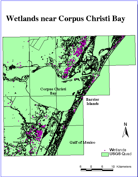
The wetlands quads that surround Corpus Christi Bay were selected and viewed showing the wetlands data detail of the barrier islands, the bay, and the outlet of the Nueces River.
The coverage of the major river basins in Texas, mjbtxc2utm2, was also obtained from the CRWR database. The data files are found at ftp.crwr.utexas.edu in the directory /home/seann/texas/ .
Here are the wetlands that have been digitized within the counties of the Corpus Christi watershed

Here are the wetlands that surround the Corpus Christi Bay
Finally, distance contours were constructed using ArcInfo and ArcView. The contour shape files, txbuf**km, and the wetlands coverages were then superimposed onto the coverage of the major river basins of Texas, mjbtxc2utm2, which shows that all of the SanAntonio/Nueces River Basin has been delineated. Several steps were required to create the contours.
First, a template for the outline of the state of Texas had to be created from the Texas counties coverage texutm. In ArcView, go into the polygon attribute table (PAT) and select the Edit/Start edit menu item. Create a new column for the dissolve item in the attribute table called newfield and assign all rows an arbitrary value greater than zero. Then use the ArcInfo dissolve command, which merges all of the individual county polygons into one large state polygon. At the ArcInfo prompt enter:
Arc: dissolve texutm texas newfield
Usage: DISSOLVE [in_cover] [out_cover] [dissolve_item ]
Dissolving texutm by newfield to create texas
Creating texas.PAT format...
Creating dissolve table...
Dissolving...
Number of Polygons (Input,Output) = 268 3
Number of Arcs (Input,Output) = 792 32
Creating texas.PAT...
A new coverage texas has been created, which is a single polygon encompassing the entire state. To show distances inland from the coast as contour lines, use the ArcInfo command buffer, with the units that belong to the coverage of interest.
Important Note: The buffer command has a problem in ArcInfo. The program should be able to buffer positive distances away from the polygon coverage as well as negative distances inside the polygon coverage. The program failed to recognize negative numbers no matter where they were entered ( at the command line or as a designated buffer item). Using positive distances with the line option solves the problem because it does not distinguish between inside and outside the polygon. It creates two equidistant lines on either side of the border. To view the double lines, build the arc coverage. The way to get around this problem and buffer inside the polygon is shown in the follow series of commands :
Usage: BUFFER
Arc: buffer texas txbuf10 # # 10000 # line # #
Buffering ...
Sorting...
Intersecting...
Assembling polygons...
Creating new labels... quit
TFinding inside polygons...
Dissolving...
Building nodes...
Creating texbuf10.PAT...
Arc: build txbuf10 line
Building lines.....
In ArcView, select the AddTheme icon and choose the arc theme of txbuf10. To remove the positive distance line, highlight the inside line to be kept by using the select icon. Then from the menu choose Theme/Convert to Shapefile. The selected line is converted into a shape file, txbuf10km, which can now be added to ArcView and displayed. Contour Shapefiles were made in 10km increments from 10 to 150km inland.
Here are the wetlands with inland distance contours to illustrate wetlands density distributions:
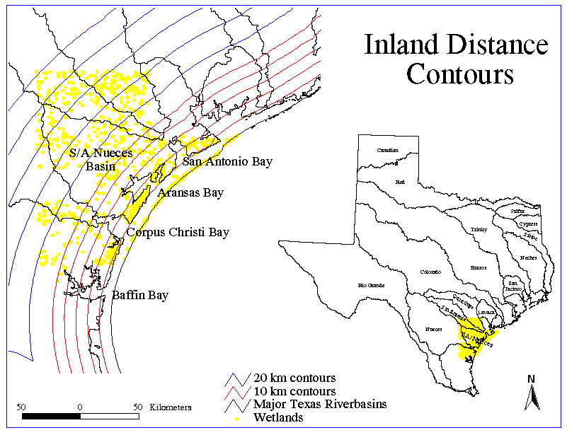
The obvious result is that the highest densities of wetland occurs along the barrier islands, and along the coastline which are in the 1st 10km and 20km, respectively. Without more data to compare, it seems that the distribution is more dispersed with no clear patterns farther inland.
One downfall that is apparent in the wetlands points attribute table is the lack of information on the size of each wetland. The wetland areas would be extremely useful, for example, to examine the percent area occupied by wetlands in a region of interest. Currently, I am trying to determine if this type of data exists at the NWI or elsewhere.
(1)Lewis, W.M. Jr., 1995. Wetlands: Characteristics and Boundaries, National Research Council Report. National Academy Press, 2101 Constitution Ave., NW, Washington, DC 20418
(2)National Wetlands Inventory (NWI) Internet site: http://www.nwi.fws.gov/
(3) CRWR database ftp site: ftp.crwr.utexas.edu
(4) United States Geological Survey (USGS) Internet site: http://h2O.er.usgs.gov/nsdi/wais/water/ .
(5)Texas United States Geological Survey (TXUSGS) Internet site: http://txwww.cr.usgs.gov/cgi-bin/nwis1_server .
The Data Dictionary is a listing and brief explanation of the coverages and Shapefiles used in this report.
Click here to go to the GIS Data Dictionary