Incorporating Satellite Imagery into a GIS
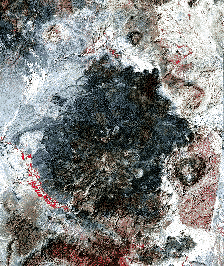
As I mentioned in my presentation, I have only just begun to experiment with satellite imagery. However, I want to present a few images here to show how satellite imagery can be a valuable addition to a GIS. The image above is a mosaic of two Landsat Thematic Mapper (TM) subscenes. The subscene on the left, covering the Big Bend Ranch State Park area, was taken from TM scene path 31/row 40, and the subscene on the right from path 30/row 40. In this image 3 bands of a possible 7 are displayed- bands 4, 3, and 2. Band 4, which senses in the near infrared portion of the electromagnetic spectrum (0.76-0.90 microns), is shown in red. Vegetation is highly reflective in this band and is thus depicted here as red. Bands 3 and 2 are shown in green and blue, respectively. This is a typical arrangement for TM bands, particularly in vegetation studies, because the resulting image mimics a color infrared composite.
However, this is only the beginning. From here, a multitude of spectral, spatial, and statistical calculations can be performed on the data to yield various types of information about the region. Consider the images below:
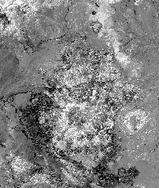
These two images are subsets of the larger image above taken from the upper left corner. The image on the left is the standard 4, 3, 2 'color infrared' composite. As stated above, vegetation in these types of composites are generally depicted in red. However, sometimes other aspects of the image can obscure this information. I thus performed an NDVI calculation on the data to create the image on the right.
NDVI, or normalized difference vegetation index, is a method by which vegetative biomass can be extracted from an image. Though generally associated with AVHRR imagery, NDVI calculations can be performed on many kinds of multispectral data, including TM imagery. To calculate the normalized difference vegetation index the values for band 3 are subtracted from band 4; this value is then divided by the sum of band 3 and 4:
[(band 4) - (band 3) / (band 4) + (band 3)].
From this calculation a single-band image is created in which the pixel values range from -1 to 1. Negative numbers indicate the absence of vegetation; positive numbers, on the other hand, indicate varying densities of vegetation.
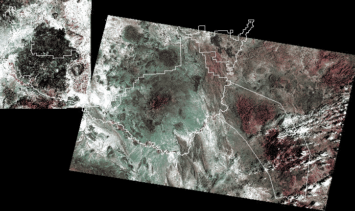
In the image on the right, pixels with positive values are depicted as light gray and white. Thus, the lighter parts of the image indicate the presence of vegetation. We know that higher elevations in semi-arid regions receive more rainfall and should thus support denser vegetation than surrounding basins and plains. Consider the map below:
The areas shaded in green represent elevations over 4,000 feet. As you can see, there is a detectable correlation between elevation and vegetative biomass. With additional calculations the biomass in the NDVI image can be quantified and subsequently compared to other images.