CE 397: Environmental Risk Assessment
Department of Civil Engineering
The University of Texas at Austin
Homework #3 - Developing Site Conceptual Models
By Lesley Hay Wilson
Computer and Data Requirements
The site conceptual model is an important framework for the analysis of sources of chemicals of concern in the environment. The potential for exposure must be evaluated for all credible pathways from sources to human or ecological receptors. The site conceptual model is a method to characterize the situation being studies and a means to communicate that understanding.
This exercise is designed to help you work through the process of building an initial site conceptual model for a hypothetical case study described below. There is also an opportunity to identify a completely new scenario and define the site conceptual model for that situation.
Computer and Data Requirements
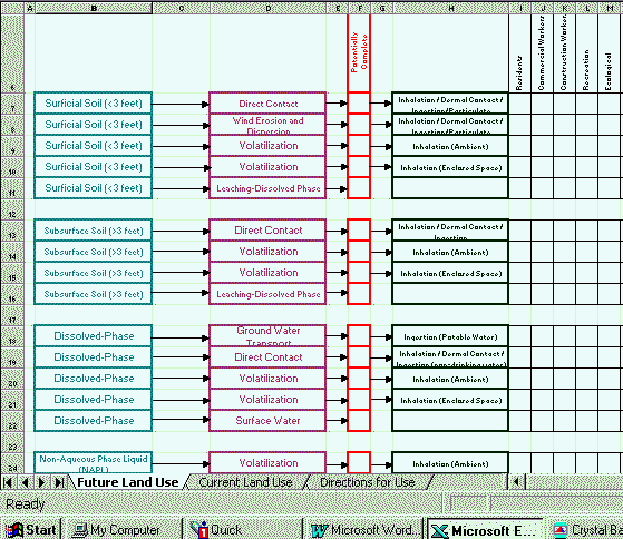
This exercise does not specifically require the use of computer software, however, an Excel spreadsheet has been provided as an example for documenting the exposure pathway decisions. The file sitecon4.xls can be downloaded from here: sitecon4.xls.
The Excel workbook contains three spreadsheets. The first two are identified for the current land use and future land use.
The third sheet provides some basic instructions. The instructions that pertain to screening level comparisons to concentrations of chemicals of concern do not apply to this exercise (They would be part of later evaluations once physical sampling had been completed).
As an example for completing the spreadsheet for current land use, suppose there were a pipeline release of gasoline at a pipeline pumping station. The release occurred 6 feet below grade. The chemicals of concern identified would be benzene, toluene, ethylbenzene, xylenes and MTBE. One potentially complete pathway would be from subsurface soils via volatilization into indoor air at the pumping station building. The receptors on-property would be the commercial workers. The portion of the spreadsheet for current land use would look like this:
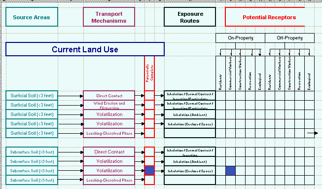
This would be only one of the potentially complete pathways at the site.
Note: If pathways or receptors are not included in the default spreadsheet they should be added.
The following sections outline the characteristics of a case study site that is a petroleum bulk storage facility (Dr. Maidment says go with what you know….). The narrative contains the type of information that you would normally have following a non-intrusive investigation (also know as a "paper audit" and site inspection). It is at this point in a corrective action project that as the project manager you would be required to develop the initial site conceptual model. Following the narrative there are specific questions to be turned-in.
You may wish to consult the BP Risk-Based Decision Process Guidance Document or the TNRCC Risk Reduction Program Guidance to complete this assignment. Both documents are on-reserve for the class in the Engineering Library (First Floor, ECJ).
Case Study for the Exercise
1. Location
The property is in a small community that is a suburb of a major metropolitan area. Over the past 10 years, this community has seen significant growth as a result of residential and commercial development. The property is bounded by Main Street to the east, High Street to the south and the Old Farm to the north and west. A lumber yard and retail home improvement store is located across Main Street and residential homes are located across High Street and to the north (See Figure 1). The property size is approximately 7.5 acres.
2. History of the Property
The property was developed as a bulk storage facility for commercial sales of petroleum products to farmers in the area. The facility was originally built on a small parcel of farmland purchased from the Old Farm in 1919. At that time, the area surrounding the property was all farmland. Over the years, both underground and aboveground tanks have been added and removed from the facility (See Figure 2). In 1953, a retail service station was constructed on the corner of Main and High Streets. The service station operated until 1979 when it was permanently closed. It is not clear from the records whether the tanks were removed at the time the station was closed, although it appears that the pavement in the area where the tanks are likely to have existed has been removed.
The currently operating bulk storage facility has six aboveground tanks and one underground storage tanks:
1 - 50,000 gallon vertical aboveground tank storing diesel fuel
2 - 17,000 gallon vertical aboveground tank storing heat oil
1 - 17,000 gallon vertical aboveground tank storing kerosene
1 - 10,000 gallon horizontal aboveground tank storing regular unleaded gasoline
1 - 10,000 gallon horizontal above ground tank storing mid-grade unleaded gasoline.
1 - 8,000 gallon underground oil/water separator
Piping is aboveground from the tanks to the pumps and is underground from the pumps to the load rack. There is a 20 X 50 foot concrete pad for used drum storage that was installed in 1979. The lot is gravel with the exception of a concrete pad under the loading rack and a 50 X 100 foot concrete pad in the area of the transport unloading connections. Surface drainage from these pads is collected in drains and directed to the oil/water separator. The oil/water separator discharges to a sanitary sewer that runs along Main Street. Records show that the oil/water separator has operated in compliance with a pre-treatment permit from the POTW. A canopy covers the loading rack area. General surface drainage for the property appears to be to the north.
The facility has a large brick building that was constructed when the facility first opened. The building contains an office at the north end and a warehouse in the remainder of the building. The warehouse has been use to store bulk (55-gallon drum) products that consist of motor oils, hydraulic fluids, and solvents and cases of antifreeze and motor oil since the facility was constructed.
There are two known releases that have been identified in the records for the facility:
In 1976 vandals damaged the tank valve on the Kerosene tank causing a release of 4,000 gallons. The release was contained in the dike area and an unknown quantity of product was recovered.
In 1985 the regular unleaded gasoline above ground storage tank was overfilled causing a release of an estimated 700 gallons of product. The release was contained in the dike area and an unknown amount of product was recovered.
Based on old plot plans, the service station was a two bay conventional auto repair facility with five underground storage tanks at the time the station was closed:
1 - 8,000 gallon regular unleaded tank
1 - 6,000 gallon mid-grade unleaded tank
1 - 4,000 gallon premium unleaded tank
1 - 550 gallon used oil tank
1 - 550 gallon heat oil tank
3. Regional Characteristics
The area is generally flat with surface drainage towards the north. The soils underlying the area are generally sand and gravel, followed by weathered clay and silty-sands overlying bedrock. There is a low yield (<3gpm) aquifer above the weathered clay with a gradient sloping towards the north. Above the bedrock is a high yield (>300gpm) aquifer with a gradient sloping towards the south. The potable wells in the area are completed in the lower aquifer. The municipal water supply system obtains its water from a well field completed in the lower aquifer approximately one mile south of the property (See Figure 3).
4. Potable Water Supply
The source of potable water to the area is mixed. A municipal water supply system and sanitary sewer system that has been installed along Main Street will supply the proposed residential developments. The municipal water system obtains its water from a well field to the south of the property (see Figure 4). However, some of the older homes and facilities in the area still have potable supply wells and septic tanks/ leach fields on their properties; including the facility and the lumberyard. The municipality does not have any specific ordinances requiring properties to be connected to the water supply system. Municipal records indicate all potable wells are completed in the lower aquifer.
5. Status of the Property
The property is to be closed and sold to a local developer who also plans to purchase several hundred acres of the adjoining farmland from the Old Farm. The developer plans to develop the area into a residential community with single and multiple family dwellings along with a small commercial/retail strip at the corner of Main and High Streets. A small park area is planned north of the bulk storage facility (See Figure 4 and Figure 5).
6. Adjoining Properties
The Old Farm has a number of wells completed in the upper aquifer for irrigation. There are three irrigation wells north and west of the property. The well immediately west of the property has had reports of hydrocarbon odors in it.
7. Questions
Answer the following questions about the case study:
(1). For the case study site as a whole, answer the following questions.
What are the potential source(s)?
What are the potential source area(s)?
What are the potential chemical(s) of concern?
What are the media likely to contain chemical(s) of concern?
What are the potential transport mechanisms?
What is the current and reasonably potential future land use of the property?
What is the current and reasonably potential future ground water use?
What are the human and ecological receptors?
What are the potential exposure routes?
(2). From the list of potential sources developed in question (1), choose a source on the case study site and develop the exposure pathway flowcharts for that source for both current and future land use. Document the chemicals of concern that are applicable for that source. You may use the spreadsheet sitecon4.xls, or another method to document your decisions about exposure pathways.
(3). Focusing on the potential source that you documented in question (2), what sampling or other field data should be collected to determine if the pathways are complete?
(4). Use the spreadsheet to analyze an environmental exposure scenario that you define. Provide the details of the source, the chemicals of concern and complete the spreadsheet for the potentially complete pathways.
Return to the Class Home Page