CE 394K.2 Hydrology
The Role of Hydrology in Urban Drainage Management
Speakers from the City
of Austin Watershed Protection Department
Overview: George Oswald, Watershed Engineering Division Manager
The jurisdiction of the City of Austin Watershed Protection Department
includes the city proper (~250 square miles), the extra-territorial jurisdiction
(ETJ) covering an additional radius of 5 miles, and parts of Hays county.
Together, this area covers approximately 500 square miles. Major sources
of revenue are ~$20 million from landowner fees, and bonds such as the
recent $25 million approved by voters for construction of the Waller Creek
tunnel.
Service Missions
-
Flood Control
-
Primary System: major waterways
-
Secondary System: stormsewers/small conveyances (e.g., regional detention,
channel modifications, property acquisition, flood warning)
-
Water Quality: source controls, structural treatment controls
-
Streambank Erosion (quantification and management): source controls, structural
restoration
Major Program Focus:
-
New Land Development:
-
Allowable development intensity (hydrologic and hydraulic models are used
to determine allowable floodway encroachment)
-
Adequacy of drainage infrastructure (streets, stormsewers, water quality,
detention basins)
-
Corrective Improvements in Older Urbanized Areas: retrofits for flood control,
erosion, and water quality management
Austin Hydrologic Issues
-
Flood control: large, infrequent storm events: 10-12 inches/24 hours (25-100
yr storm)
-
Water quality and erosion management: small, frequent storm events: <2
inches/24 hours (90% annual total volume)
-
Application of simple hydrology for small areas (<100 acres) using the
rational method
-
Application of the unit hydrograph and channel routing for larger watershed
areas using HEC-1/HMS with SCS Unit Hydrograph
Role of Hydrology in Flood Control Mission: David Walker, Floodplain
Manager
The Austin area is extremely flood-prone. The cause is a combination of
terrain characteristics (Edwards aquifer uplift zone), and climate (low
pressure zones from the Pacific sucking up moisture from the Gulf of Mexico).
Therefore, hydrologic analysis is very important. The primary tools of
hydrology are:
-
direct observations
-
statistical analysis
-
computational methods for precipitation transforms and routing
Hydrology provides estimates of:
-
peak flow
-
timing (important for larger drainage areas)
-
total runoff hydrographs
-
statistical probability of events (used for risk/cost analysis in drainage
structure design)
These are the basic inputs for hydraulic analyses/floodplain delineations
and design of hydraulic structures. They are needed to analyze existing
conditions and project the impacts of future/proposed conditions. Typical
applications include the following:
-
Prevent creation of flood hazards
-
regulate land development
-
review plans
-
propose, enact, & enforce local ordinances and regulations
-
Mitigate existing flood hazards
-
structure buyouts
-
attempt to alter basin hydrology (detention)
-
attempt to alter conveyance (channel modifications, maintenance, bridge
enlargements)
-
Provide flood insurance: administer National Flood Insurance Program
-
Provide flood warnings: model conditions based on synthetic storms and
make on the fly judgement calls
-
road closures
-
evacuations
-
reduce contents loss
Channel Instability and Stream Bank Erosion: Mike Kelly, Erosion
Control Engineer
High stream flows can cause a lot of damage, but the frequency is low.
As such, the overall effect on stream shape is low. We're more interested
in storms with sufficient frequency and magnitude to shape channels through
sediment redeposition. Channel equilibrium is described by the following
relationship:
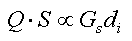 , where:
Q = flow
S = bed slope
Gs = sediment load
di = sediment size
In the typical scenario, Q increases due to a storm. The result is generally
a combination of decreased bed slope, increased sediment load, and increased
sediment. Some applications are as follows:
1. Land development. The law requires that the channel should withstand
changes from increased flows resulting from land development. Hence, detention
ponds are sometimes used as a tool to reduce flows.
2. Remediation. Channel geometry changes in response to changes in shear
stresses:
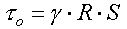 and
and  where:
t = shear stress
w = stream power
g = specific weight
R = hydraulic radius
S = bed slope
Channel degradation typically occurs by the following process. High
flows and frequency cause an increase in water power, which in turn leads
to higher sediment loads, which results in increased cross-sectional area
(deeper channel). The channel can now convey more flow. But this comes
at a cost of steep stream banks devoid of vegetation and decreased slope
stability. There are two common solutions:
-
Reinforce the channel with new material (e.g., concrete). But this tends
to adversely affect both the aquatic habitat and aesthetic value of the
stream.
-
Excavate the channel to form larger cross-sections, while stabilizing the
slopes.
Return to Class
Home Page