Eric Tate
May 1998
REMOTE SENSING WITH DIGITAL ORTHOPHOTOS
Introduction
In recent years, many technological advances have been made in the field of
photogrammetry, the process of making maps using photographs. Perhaps the
most significant achievement has been the refinement of methods to produce
digital orthophotographs. Digital orthophotos are scaled aerial photographs,
which can be used (among other things) as a base map in a GIS or as a tool
to revise digital line graphs and topographic maps. The procedure used to
create digital orthophotos, called ortho-rectification, requires aerial
photographs and a digital terrain model as inputs. In the following paragraphs,
the procedure is described.
Aerial Photography
The first step in digital orthophoto production is to take aerial photographs
of the land surface. While taking the photographs, the plane meanders over a
certain area, such that it's covered by overlapping photographs. Typically,
the photos are taken with a camera with a 6-inch focal length lens at an
altitude of 15,000 feet; this generates photographs with a scale of 1:30,000.
The film diapositives are later scanned with a precision image scanner to create
a raster image file.
Digital Terrain Model
The digital terrain model (DTM) can either come from an existing source or it
can be developed from the aerial photography. The aerial photos are taken using
a stereoscopic camera, with which two pictures of a particular area are simultaneously
taken, but from slightly different angles. The overlapping area of the two
resulting photos is called a stereo pair. Using a computer called a stereoplotter,
the stereo pair can be viewed as a single image with the appearance of depth or
relief. Ground control points are established based on ground surveys or aerial
triangulation and are viewed in the stereoplotter in conjunction with the stereo
pair. In this setting, the image coordinates of any (x,y,z) point in the stereo
pair can be determined and randomly selected and digitized. These points, in
conjunction with the control points, comprise the data points for the DTM. The
accuracy of the final digital orthophoto will depend in large part on the point
density of the DTM.
For a digital representation of the terrain, a triangular
irregular network (TIN) model is often used. In the TIN model, a triangular
mesh is drawn on the control and determined data points. To form the TIN, a
perimeter around the data points is first established, called the convex hull.
To connect the interior points, Delaunay triangulation is used, in which a surface
approximation is generated where triangles are created with all internal angles
as nearly equiangular as possible. Each resulting triangle is a planar surface.
By integrating all of the triangles over the domain, a surface is created.
Additional elevation data such as spot elevations at summits and depressions
and break lines are also collected for the TIN model. Break lines represent
significant terrain features like a lake or cliff that cause a change in slope.
TIN triangles do not cross break lines. One reason the TIN model is used is
that it requires a much smaller number of points than a gridded DTM does in order
to represent the surface terrain with equal accuracy.
Orthophoto Rectification
Conventional aerial photographs have limited use in GIS because they are not true
to scale. When you look at the center of an aerial photograph, your view is the
same as if you were looking straight down from the aircraft. But as you look
toward the edges of the photograph, the view of the ground is no longer straight
down, but from an angle. This is called a central perspective projection; scale
is true at the very center of the aerial photograph, but not elsewhere. In order
to create a scale correct photograph that can be accurately measured, an orthographic
projection is necessary, in which the view is straight down over every point in the
photograph.
The TIN surface is used to orthogonally rectify the scanned image
file. By combining the two data sources, each image pixel has a known position and
intensity value. In the rectification process, the intensity value for each pixel
is re-sampled using a space resection equation, removing image displacements caused
by central perspective projection, camera tilt, and terrain relief. The individual
photographs are then clipped and seamlessly joined together over the entire study
area. The result is a digital image that combines the image characteristics of a
photograph with the geometric qualities of a map--a true to scale photographic map.
The typical digital orthophoto is a quarter quadrangle image cast in the Universal
Transverse Mercator projection. Ground/pixel resolutions can be as fine as 1 meter.
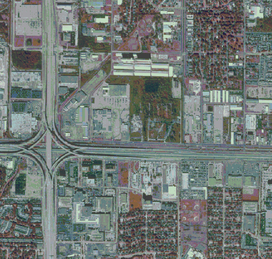
Alief, NE DOQQ (2.5-meter resolution)
Benefits
Digital orthophoto quarter quadrangles (DOQQs) have many uses
in the GIS environment. Some DOQQ benefits include the following:
- May be used as a GIS base map for a variety of uses,
including urban and regional planning, revision of digital line graphs and
topographic maps, creation of soil maps, and drainage studies.
- More cost effective and display more surface features
than conventional maps.
 Return to Eric's home page.