![]()
Applying TxRR to Texas Coastal Basins
prepared by: Victoria Samuels
prepared for: Surface Water Hydrology, CE 394K.2, Spring 2001
Background:
|
|
|
One of the main objectives of the Texas Water Development Board (TWDB) is to study and determine how much water will be needed to maintain Texas's streams, rivers, bays and estuaries. This program is being investigated concurrently by the TWDB, the Texas Parks and Wildlife Department and the Texas Natural Resource Conservation Commission (TNRCC). In this study, monitoring data and studies will be compiled to evaluate the needs for instream flows and freshwater inflows to estuarine systems in Texas. Unfortunately, many of the coastal watersheds are ungaged and difficult to model and simulate with traditional rainfall/runoff models.
The Model:
In order to model the ungaged coastal areas, the TWDB has devised the Texas Rainfall-Runoff Model (TxRR). This model is able to estimate runoffs from ungaged watersheds and streamflows on a daily basis. It does this by analyzing the soil moisture of the area continuously and direct runoff on an event by event basis.
TxRR's components are similar to the Agricultural Research Service (ARS) model, the Soil Conservation Service (SCS) Curve Number method and the SCS Unit Hydrograph. However, recent changes have been made to the model which modify these methods. Instead of one annual depletion factor, TxRR employs 12 monthly depletion factors. Also, the Unit Hydrograph method has been changed to the Gamma function and parameter optimization has been altered from Newton's method to Genetic Algorithm.
The focus of TxRR is on the water balance, illustrated by the following figure:
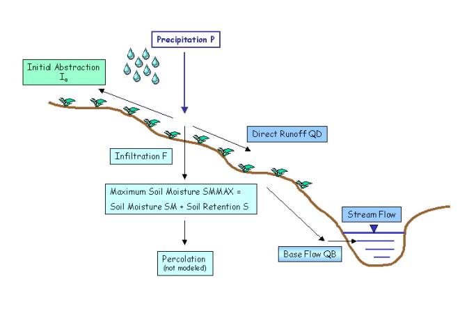
A rainfall event occurs and the preciptation P is partitioned into initial abstractions Ia, infiltration F and direct runoff QD. The infiltration process is characterized by a maximum soil moisture amount, SMMAX which is separated into the soil moisture SM and the remaining soil retention S. The soil moisture parameters additionally influence the base flow QB. The base flow and direct runoff together combine to equal the stream flow.
The ungaged watershed is modeled by relating the curve number of a gaged watershed nearby as well as the maximum soil moisture values. The specific equation is:
SMMAXU = (CNG/CNU) * SMMAXG
where the U represents the ungaged watershed parameters and G represents the gaged watershed parameters. This relationship holds because the curve number (CN) acts as an indicator of soil retention and the ratio of curve numbers is inversely proportional to the soil retentions.
Study Area:
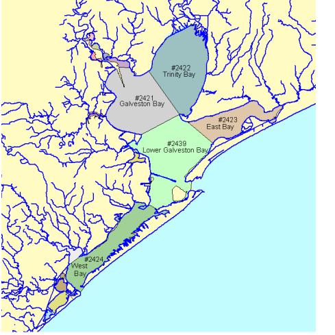
My graduate research deals with the coastal area surrounding Houston, TX, an ideal environment for the application of TxRR. The area, Basin Group C according to the TNRCC, contains partitioned bays and estuaries with definitive boundaries. Part of my research involves collecting various soil and land cover data which is necessary to develop curve numbers. Therefore, the study area for this project is Basin Group C in Texas, as seen in the following figure:
Objectives:
I plan to apply the TxRR model to the bays and estuaries in Basin Group C. I hope to use the methodology developed by Richard Gu, Jerry Perales and Dr. Maidment as a point of departure in developing a new process for evaluating the rainfall/runoff relationship into these bays. I will use the new Visual Basic interface for TxRR to input and manipulate this data and provide hydrographs and results for the bays.
In order to perform these tasks I have and will continue to gain information from many sources which I will acknowledge and reference:
User's Manual for The TWDB's Rainfall-Runoff Model, Junji Matsumoto, PhD. PE. Texas Water Development Board
Developing a GIS-TxRR Model, Jerome Perales, Richard Gu and David R. Maidment. Center for Research in Water Resources
Barney Austin, Texas Water Development Board
Geographical Database Development for the TxRR Surface Water Model, Richard Gu