GIS in Water Resources
Fall 2010
Homework #1
1. Map Projection Parameters
The map below shows Utah and the display parameters of the State Plane coordinate system for the Utah Central Zone.


(a) Sketch on the map the standard parallels, the central meridian and the latitude of origin of this projection.
(b) For this projection, what are the coordinates of the origin (fo, lo) and the corresponding (Xo, Yo) ?
(c) What earth datum is used in this coordinate system?
(d) What map projection is used in this coordinate system?
2. Locations on the Earth
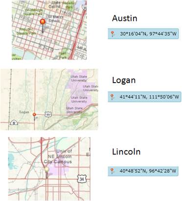
Using ArcGIS Explorer and putting in the names of Austin, Logan and Lincoln reveals the following designated locations for these cities. Convert these locations into decimal degrees.
3. Distances on the Earth
Calculate the great circle "curved earth" distance between each combination of cities (i.e. Logan to Austin, Austin to Lincoln and Lincoln to Logan). Assume a spherical earth with radius 6378.137 km.
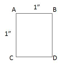
4. Sizes of DEM Cells
Digital elevation models are stored in geographic coordinate systems with units of degrees, minutes and seconds. When applied, they are projected to a coordinate system in which the (X,Y) coordinates are in meters. Suppose you have a DEM cell that is 1” x 1” (1 arcsecond x 1 arcsecond) in latitude and longitude and that you are working on a spherical earth with radius 6378.137 km. Calculate the corresponding distances AB and AC in meters, and the area ABCD in square meters, for this cell on a spherical earth, at Austin, Logan and Lincoln.