Using Benthic
Macroinvertebrates and GIS to Assess and Manage Watershed Health of the
By Jennifer Thompson
Introduction
Monitoring aquatic communities and more specifically,
benthic macroinvertebrate populations of
rivers, lakes, and streams, is a common practice implemented by local, state
and federal authorities to help assess and monitor the health of waterbodies. Aquatic benthic macroinvertebrates are
bottom-dwelling (“benthic”) organisms, living and foraging for food on the
substratum of a waterbody. A majority of
benthic macroinvertebrates are aquatic insects, and can be easily seen with the
unaided eye (“macro”). The diversity,
type, and abundance of these organisms are thought to be a reflection of water
quality and the local hydrology of a waterbody.
The use of GIS to spatially represent monitoring locations and bug and
water quality data with the power of
overlaying watersheds and other variables (e.g. land use) can reveal
subtle relationships that can be used to help local land managers identify
areas of concern, focus monitoring and remediation strategies, and understand
critical links between the hydrology and biology.
As part of the Clean Water Act Section 303(d) each state is
required to monitor and assess their state’s surface waters and report water
quality with regard to their findings in a report to the U.S. Environmental
Protection Agency (EPA) every two years.
The Texas Commission on Environmental Quality (TCEQ) keeps track of
these data for the State of
Objectives
Using surface water quality and macroinvertebrate data, in
addition to multiple shape files provided by the USGS, this study will focus on
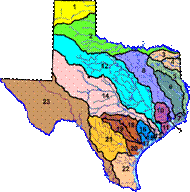
the watershed health of the Colorado River Basin (shown here as region 14).
This project will attempt to meet the following objectives:
·
Provide a spatial representation of monitoring
sites and data; create a comprehensive geodatabase
·
Provide a temporal representation of data
collected from 1995-2004
·
Learn about state criteria, screen and water
quality standards, and how the
Upon starting this project, I quickly came to realize the rudimentary nature of the State’s data collection systems into multiple databases, and thus the need to develop a user-friendly way to view and relate spatial and temporal representations of biological and water quality information. Therefore, the goals of the project were pared to adapt to this situation and were focused to meet a more immediate objective, as to what would a comprehensive biological database look like.
Methodology
Currently, the State’s water quality and biological data is available online at:
http://www.tnrcc.state.tx.us/water/quality/data/wmt/samplequery.html
The current form of data files available for viewing/downloading for one category of data, e.g. surface water quality, consist of two files; an event and result file, in which the two files must be joined to form one relational database to obtain all data related to one sample event. Furthermore, all meta data associated with the result and event file is also stored in separate files. Using Microsoft Access, I made relational databases of bug and water quality data, specific to the parameters I chose, and imported them into ArcCatalog to form one geodatabase. The geodatabase consisted of both biological (benthic macroinvertebrate data) and surface water quality data from 1995-2004.
In addition to building and importing the relational databases created in Microsoft Access into ArcGIS to form one geodatabase, several layers and coverages were also imported to create the foundation for making the basemaps. Hydrologic Cataloging Unit (HUC) files for water resource region 12 and EPA river reach files for region 12 were downloaded, converted to shape files, and used for providing the spatial context for the basemaps. These files can be downloaded from:
http://water.usgs.gov/lookup/getspatial?huc250k
Monitoring locations were assigned by importing the latitude/longitude locations (in decimal degrees) into Arc Catalog and ArcMap, and assigning XY data using ‘Tools’.
To evaluate the “health” of the
Results
There is not enough available data to determine the health
of the
Due to the few monitoring locations and infrequent sampling events associated with them, temporal representations did not show any real relevance. Furthermore, utilities such as Tracking Analyst were thus not applicable.
Discussion
The current form of retrieving information from the State’s
website and evaluating the health of
As a start, I wanted to see and verify the utility and power
of GIS in using surface and biological data to assess watershed health. I decided to spatially and temporally represent
an extensive dataset of bug data from the City of
Using shape files of central Texas counties and subwatersheds
within the COA jurisdiction, provided by the City of

Figure 1. EII Benthic Macroinvertebrate Scores, City of

Figure 2. Total EII Watershed Scores, City of
At a first glance, when spatially represented, the benthic
macroinvertebrate/aquatic life use scores and total EII scores for each
watershed generally appear to correspond quite well with what one might
expect. Following closely along the
Importance and Future
Work
The power of GIS to spatially and visually relate the results of such monitoring programs can be used by watershed managers to identify areas of concern, focus monitoring efforts, and track the success of remediation efforts. The COA in particular uses these results to prioritize subwatersheds for addressing Capitol Improvement Projects (CIP’s), monitoring programs, and planning in general.
Future work should include linear referencing all monitoring
locations in a watershed, whereby field staff and information managers could
query specific sites and identify exactly their location for either site visits
or for more in depth statistical analyses.
Additionally, incorporating and linear referencing flow gaging stations,
either USGS or agency dependent (e.g. FEWS for COA), along with consistent, routine
biological and habitat assessments could ultimately help to reveal subtle links
between the hydrology and biology. In
In summary, streams and rivers harbor extremely complex and dynamic ecosystems that provide our communities with clean water, energy, fish and other recreational activities. Rivers also provide freshwater to the bays and estuaries along the coast, providing important nutrients and freshwater to coastal nurseries. To understand what parameters are most important to these communities, it is important from a biological perspective to not only calculate indices and spatially represent water quality data, but to incorporate more detailed physical habitat quality parameters into biological geodatabases and to be able to track and monitor their changes as well. With a comprehensive database, one could use GIS to interpolate IBI’s and habitat characteristics as one moves downstream. Furthermore, applying land use coverages may help to explain if and how urbanization is affecting local streams and waterbodies. Finally, it should be apparent that much more data collection is necessary (especially habitat data), and on a more routine basis to build a comprehensive geodatabase and use the applications of GIS and ArcHydro to assess and mange the health local and state water bodies.
References
Herrington, Chris. 2003. Changes in Environmental Integrity Index values (1996-2002).
City of
Development Review,
TCEQ. 2000.
Standards.