Rabat, Morocco
Report of Francisco Olivera's Visit to the Direction Generale de l'Hydraulique
(DGH) of Morocco
October 23 - November 2, 1995
The Souss basin is a 19,000 Km2 area located East from the coastal city of Agadir, Morocco. The basin expands from the Atlantic Ocean for approximately 200 Km and is surrounded by the Atlas Mountains on the Northern side, and Anti-Atlas mountains on the Southern side. The topography shows a relatively flat plain in the central portion of the basin, and a steep mountainous landscape around it. Three reservoirs, Aoulouz, Abdel Moumen and Dkhila are found in the watershed, and are used for flow regulation and aquifer recharge.

In recent years, much agriculture has developed in the central plain, which contrasts with the natural dryness of the soil. Nevertheless, agriculture is not a new economic activity in the area. Traditionally, water for irrigation was obtained by digging almost horizontal galleries to the groundwater table, and then letting the water flow by gravity down the gallery. At present, water is pumped from the subsurface. According to the Regional Office of the DGH at Agadir, in the last 40 or 50 years pumping has depleted the water table, in some places, as much as 100 m; and, as an average, the water table is lowered at a rate of approximately 1 m per year. However, this information has not been confirmed by the few borehole data that I have reviewed. Besides increasing considerably the pumping costs, lowering the water table means that the system tends to get to a point in which the availability of water would not satisfy the demand. The systematic depletion of the water table implies that the system is not in long-term equilibrium (i.e. outflow is consistently greater than inflow).
Also, because of the high evaporation and infiltration rates in the central plain, the rivers tend to dry before reaching the main stream. In general, runoff occurs only after consecutive rainy days and, mostly, the horizontal movement of water takes place in the deep groundwater system. However, a surface water model is required to describe the infiltration process in the streams.
From the hydrologic modeling viewpoint, the conditions mentioned above lead us to two important conclusions:
The USGS digital elevation model (DEM) with a resolution of 30" (approx. 1 Km) was used as the basis for the topographic analysis. The ANU average annual precipitation with a resolution of 3' (aprox. 5.5 Km) was used to estimate the potential water resources in the area.
All coverages and grids were projected into Lambert Projection. Zone 2, according to the standard projections of Morocco, was selected because most of the Souss basin is included in this zone. By setting all the coverages in Lambert Projection Zone 2 we were able to utilize the maps developed by the Division of Cartography of the Ministry of Agriculture and Agrarian Reform of Morocco, and the coordinates used by different government agencies.
Starting from the USGS DEM, streams with a drainage area greater than 500 Km2 (500 grid cells) were delineated. With this threshold value, the Souss river and its main tributaries (i.e. Issen, El Mdad, Tifnoute, Immerguen, Arrhen and Awarga) could be identified. After comparing the delineated with the digitized streams, it was decided that the delineation was satisfactory and that the disagreement fell within an acceptable margin of error (arround one grid-cell size). A total of 19 sub-watersheds, with an average drainage area of approximately 1000 Km2, were also delineated. Arc and polygon coverages of the streams and sub-watersheds were generated, so that a one-to-one relation (given by the grid-code attribute) can be established between lines and polygons.
Precipitation was taken from the ANU average annual precipitation grid. This grid was projected and resampled in order to have the same cell size of, and to snap to, the DEM grid.
Finally, a weighted flow accumulation grid, having the precipitation as weight, was calculated. From the physical point of view, this grid represents the potential water resources at a certain location (i.e. without considering any type of losses) and is used as a reference value.
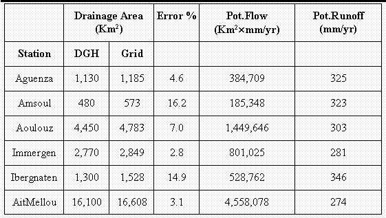
The drainage areas of six flow gauging stations of the watershed were also delineated. The error in the drainage area according to the DGH records and to the Arc/Info-Grid delineation, as well as the potential flow (weighted flow accumulation) and the potential runoff (average precipitation in the drainage area) are presented in the table. According to this table, the precipitation decreases as we go downstream (see last column), which confirms observed precipitation records.
As a first approximation, a steady state analysis is recommended. For the surface water system, a relation between the potential runoff Rp (mm/yr) (i.e. average precipitation in the drainage area) and the actual runoff Ra (mm/yr) (i.e. fraction of the potential runoff that runoffs), in five flow gauging stations, was found. This relation is given by
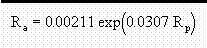
and has a regression coefficient r2 = 0.96.
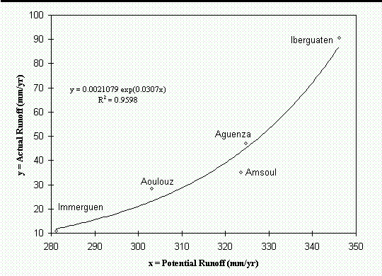
This equation is limited to drainage areas of 400 - 5000 Km2, with potential runoff of 280 - 350 mm/yr. Accordingly, the runoff coefficient c is given by
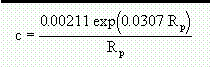
With this equation, it is posible to estimate the actual runoff Ra = c Rp at any location of the watershed, provided that the constraints of area and runoff are observed. For locations that do not satisfy the constraints, a routing process that considers losses in the streams has to be used.
A next step would be given by an unsteady flow model with a time period of a year. With this time period, the model will not be able to predict seasonal changes in the water availability, but will estimate the evolution of the system with time. For modeling purposes, the watershed is subdivided into a number of subwatersheds and the continuity and momentum equations are applied to each of these units. Note that the units are the same for both, the surface and the subsurface, water systems.
The model starts calculating the mass balance equation
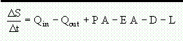
where S (m3) is the water stored in the unit, Qin (m3/yr) and Qout (m3/yr) are the inflow and outflow due to the horizontal movement of the water, P (m/yr) is the areal-averaged annual precipitation, E (m/yr) is the areal-averaged annual evapotranpiration, A (m2) is the unit area, D (m3/yr) is the annual demand (i.e. water comsumed that does not come back to the system), and L (m3/yr) are the losses in the stream due to evaporation.
Storage S, precipitation P and demand D can be obtained from DGH records; and losses in the stream L can be assumed negligible compared with the amount lost due to evapotranspiration EA. Finally, after developing a groundwater model, the momentum equation (Darcy's law) can be used to estimate the subwatershed outflow Qout based on the water table gradient. Note that the inflow Qin is just the sum of the outflows Qout of the sub-watersheds located inmediatly upstream.
Consequently, the evapotranspiration term E can be estimated as
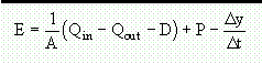
where the last term of the RHS is the change in water table elevation per year. The change in water table elevation can be obtained from borehole measurements.
(1) This report is part of the United Nations Educational, Scientific and Cultural Organization - Food and Agricultural Organization, University of Texas at Austin and Direction Generale de l'Hydraulique of Morocco project Using Geographic Information Systems for Water Resources Management