
Figure 1. Model Segmentation.
The goals of this exercise are to show you how to use BALANCE, the map based surface water quality modeling software for ArcView. The exercise is not intended to serve as a user's guide. Detailed instructions are provided in the BALANCE documentation which serves as a user's guide.
You will use BALANCE to model Salinity in the Corpus Christi Bay system and compare it to observed salinity values. Then you will use the model to study a current policy issue: Freshwater inflow from the Nueces River. You will study the effect of the freshwater inflow from the Nueces River on the salinity in Corpus Christi Bay. How sensitive is the salinity to freshwater inflow from the Nueces River?
To complete this exercise you need ArcView Version 2.1 or 3.0 running on a PC or UNIX workstation. ArcView is GIS software distributed by the Environmental Systems Research Institute, Inc. (ESRI). You also need BALANCE, the modeling software, and the model input data. Those files can be downloaded via anonymous ftp from ftp.crwr.utexas.edu/pub/crwr/gishydro/balance.
Note: If you are new to ArcView you might want to do the exercise entitled Introduction to ArcView.
The system is in the form of an ArcView project which can be opened in ArcView like a file. Start ArcView and load the .../gisfiles/balance.apr project. BALANCE consists of several programs or scripts which can be accessed through buttons on the View button and toolbars.
You might want to save the project on the hard drive of the computer you are working on, because you can not save the modified project to the CD.
In addition to the project you will need to load the data. The data files are modified during program execution and therefore have to be copied to the hard drive of the computer you are working on. Copy the following files to your hard drive:
Create a new view and add the ccbfnode, ccbfline and ccbfpoly shape files. The data files contain all the data needed for BALANCE to model salinity as well as observed salinity values for each segment. The node theme (ccbfnode) is not really used by BALANCE, but is useful because it displays the endpoints of the lines in ccfline. Figure 1 shows the model segmentation.
Make the polygon theme (ccbfpoly) visible. Double-click on the theme in the legend to bring up the legend editor. Chose 'graduated color' and pick observed salinity ('sm') as the classification field. A gray monochromatic legend works well. Note that the salinity concentration increases as we go from north to south. That is due to the evaporation, precipitation and runoff gradient from north to south. The evaporation in the southern part of the system actually exceeds precipitation and freshwater inflow. To close the water mass balance that part of the system receives a net (saltwater) inflow from the adjacent segments resulting in the system being hypersaline. The salinity is higher than the ocean. Figure 2 shows the observed salinity.

The input data files have all the parameters required to model salinity in the system. Highlight the line and polygon themes in the legend and click on the 'B' button. You are prompted to configure the units. Chose yes and pick the SI system of units. You are then prompted for the run control parameters as shown in Figure 3.
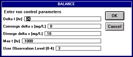
Supply the following values:
First Run Parameters:
Ooops! We are getting a message that the program diverged. This is numerical instability. What essentially is going on is that our time step is larger than the response time for (at least) one of the segments. The segment has a boundary which inputs or outputs mass at a large rate causing its concentration to jump up or down, before its other boundaries are given a chance to adjust their mass fluxes. You can see where the instability occured if you now color the segments based on modeled salinity (s). Let's try reducing the time step (run control parameter Delta t) to 12 hours. This run might take a while. To reach the convergence criterion of 0.1 mg/L took about 30 minutes on a Pentium Pro PC.
Second Run Parameters:
This should have worked just fine. Color the segments based on modeled salinity (s). Figure 4 shows an example.

A good way to compare modeled and observed salinity is to create a map of modeling error. Go to the attribute table of the polygon theme and start editing it. Select the concentration difference field (sd) and calculate it to be the difference between the modeled and observed salinity (s - sm). Then stop editing the table and save it. Color the legend of the polygon theme using the concentration difference field. A blue to red dichromatic coloring scheme works well. This way areas were the salinity is overestimated are red and areas were the salinity is underestimated are blue. Figure 5 shows an example.

BALANCE has a plotting utility which plots the mass fluxes in the View. Make sure the line (ccfline) and polygon (ccbfpoly) themes are active. Then click the 'P' button. Figure 6 shows an example.

Freshwater inflow from the Nueces River can be controlled by release from Lake Corpus Christi. The lake serves as drinking water supply to Corpus Christi and is used to ensure drinking water during drought conditions. The freshwater inflow from the Nueces River effects salinity in Corpus Christi Bay which is important from a biological viewpoint. Where should the water go in a drought? To answer the question we need to know how sensitive the system is to freshwater inflow from the Nueces River. We can use the model to answer the question.
Let's examine the effect of doubling the freshwater inflow from the Nueces River. Increase the inflow from the Nueces River by 10 m^3/s. You have to add 10 to all the lines from the most upstream interface line in Nueces Bay to the Gulf of Mexico. Figure 7 shows the lines highlighted in red.

To vary the flow across a line click on the 'M' tool button, highlight the line theme (ccbfline) by clicking on it in the legend and then click on a line. An edit dialog box will come up. Figure 7 is an example.
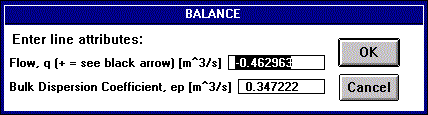
Be careful when assigning flow across an iterface line. The direction is determined by wether the value is positive or negative. Check the black arrow being drawn on the map while the dialog box is up. That arrow points in the positive flow direction. Before you model the high flow conditions make a note of the salinity in Corpus Christi Bay (ccbn and ccbm segments). Then rerun BALANCE. Compare the results to the previous run.
Repeat the exercise by reducing the inflow to 50% of its original value. Subtract 15 m^3/s from the same lines. Note that this inflow does not exceed the net evaporation in the system. The flow across some lines has to be reversed. Be careful to assign the right sign. Before you run the model make a note of the salinity in the bay. The system should turn hypersaline. The salinity in the bay should be larger than that of the ocean. Is this the case?
What are the results of you analysis? Does the freshwater inflow from the Nueces River have an effect on the salinity in Corpus Christi Bay? What are your recommendations to the city?