University of
Texas at Austin
Center for Research in Water Resources
Project: System of GIS-Based Hydrologic and Hydraulic Applications for
Highway Engineering
Sponsored by: Texas Department of Transportation (TxDOT)
Principal Investigator: David R. Maidment, Ph.D.
Project Manager: Francisco Olivera, Ph.D.
Graduate Research Assistant: Juling Bao
by Francisco Olivera and Juling Bao
An ArcView Extension is a consistent set of documents (views, tables, charts, layouts and scripts), tools and menus assembled together to add specific user-defined capabilities to ArcView. An extension can be designed in such a way that its use is not limited to any specific spatial-data set, allowing the user to in any other region provided that the necessary data are avilable, and that the peak discharge equations are corrected in the corresponding script.
An ArcView extension for estimating watershed parameters and peak discharges, according to the TxDOT Statewide Regional Rural Regression Equations, has been developed.
For developing and testing the extension, spatial-data of the State of Texas were used. These data were obtained from different sources and processed in different forms as explained below. To assemble a consistent data set, all spatial-data were projected into Albers Projection with cell-size equal to 500 m. The topography of the study area within the United States is described by the 15’ DEM, and by the North America 30’ DEM for the northern part of Mexico. The digitized stream network is taken from EPA’s river reach file RF1. The hydrologic region grid was produced by rasterizing the hydrologic-region polygon coverage developed the USGS. The runoff curve number grid was obtained using the USGS land-use/land-cover coverage, and STATSGO soil data. Scanned USGS maps of the State of Texas, at a scale of 1:2'000,000, are used as background.
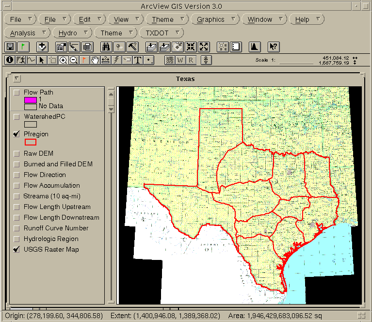
Figure 1: ArcView window displaying the USGS raster map image, and the hydrologic regions coverage for the entire State of Texas.
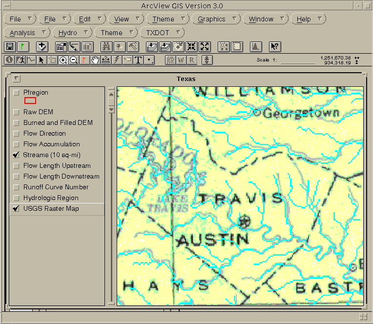
Figure 2: ArcView window displaying the USGS raster map image and the streams grid for Travis County.
The extension has been deloped to calculate watershed parameters and peak discharges according to the TxDOT Statewide Regional Rural Regression Equations. The watershed parameters calculated are: area, channel slope, length of longest flow-path, shape factor, average curve number and hydrologic region. Peak discharges are calculated for different return periods: 2, 5, 10, 25, 50 and 100 years.
The extension consists of the following processes:
To use the TxDOT extension, you need to load first the Spatial Analyst extension. At present, the TxDOT extension consists of:
To load the extension copy txdot.avx to your working directory,
which in most cases is C:\TEMP. After loading it, the pull-down menu TXDOT
and the tool buttom ![]() will appear in the top of the screen (see Figure 3).
will appear in the top of the screen (see Figure 3).
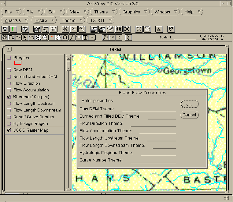
Figure 3: By clicking on TXDOT/Properties a dialog box called Flood Flow Properties pops-up.
By clicking on TXDOT/Properties a dialog box called Flood Flow Properties pops-up (see Figure 3). All the empty slots should be filled with the name of the grid theme (not necessarilly the name of the grid) according to the following guidelines:
After the name of the grid themes has been entered, the watershed parameters
and peak discharges can be calculated by clicking the buttom ![]() .
A report message box with the watershed parameters and peak discharges
pops-up (see Figure 4).
.
A report message box with the watershed parameters and peak discharges
pops-up (see Figure 4).
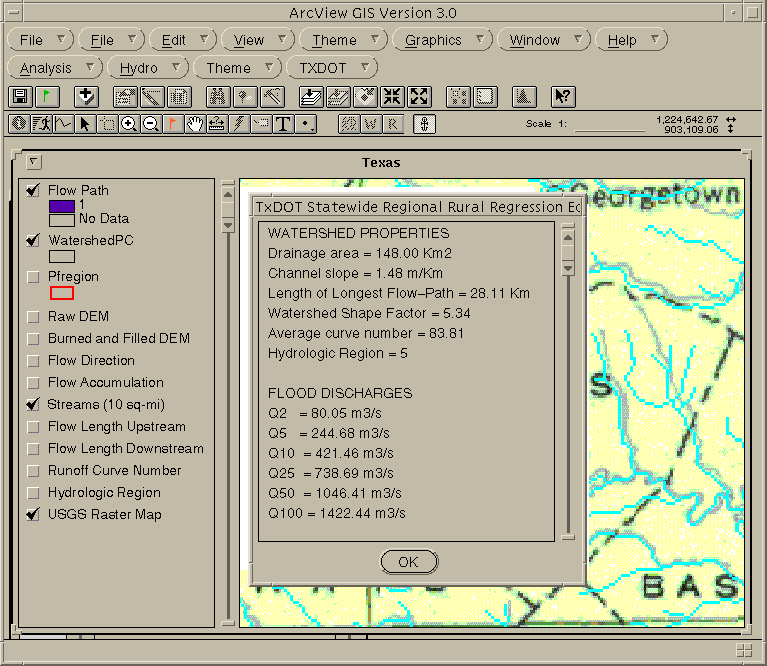
Figure 4: Watershed properties and flood discharges report message box.
After clicking the OK buttom of the report message box, the watershed is displayed as a transparent polygon with black outline, and the longest flow-path as a grid with transparent cells everywhere but in the channel where the color is defined randomly (see Figure 5).

Figure 5: Watershed boundary and longest flow-path.
This Demo ArcView Project would allow you to work with the extension applied to the Travis County, Texas, and surroundings.
If you are not working from the GISHydro97 CD-ROM, download the directory tx_wppd (approximately 15Mb) using anonymous ftp from ftp.crwr.utexas.edu/pub.
Open the ArcView project txdot3.apr located in the directory /runoff/gisfiles/tx_wppd of GISHydro97, or in the directory tx_wppd you just downloaded . The project will locate and enable the extension automatically, so that you do not have to worry about that.
Click on the menu TXDOT/Properties and fill the slots in the following way:
In the View window, zoom to the area you want to work on. Click on the menu Analysis/Properties and in the Analysis Extent slot chose Same as Display. The smaller the analysis extent, the faster the calculations, but keep in mind that the entire watershed has to fit within the analysis extent.
Click on the tool buttom ![]() and then on the point of the View window of which you want to delineate
the watershed. You will get a report message window with the watershed
parameters and peak discharges similar to that shown in Figure 4. After
clicking OK, the watershed and longest flow-path will be displayed as shown
in Figure 5.
and then on the point of the View window of which you want to delineate
the watershed. You will get a report message window with the watershed
parameters and peak discharges similar to that shown in Figure 4. After
clicking OK, the watershed and longest flow-path will be displayed as shown
in Figure 5.
The following problems have been observed:
Hope you like the exercise!!!
If you have questions or comments please e-mail Francisco Olivera at folivera@mail.utexas.edu
These materials may be used for study, research, and education, but please credit the authors and the Center for Research in Water Resources, The University of Texas at Austin. All commercial rights reserved. Copyright 1997 Center for Research in Water Resources.
Go to Francisco Olivera's homepage
Go to David Maidment's homepage
