Water Rights in the Lavaca Basin
by Karen Boles
Email: kboles@mail.utexas.edu
Introduction
The purpose of this report is to examine the potential effect of water rights on the availability of water in the Lavaca Basin in the southeastern part of Texas. The method used to conduct this analysis involves several steps which are as follows: 1) process the digital elevation model (DEM) 2) burning in the stream network 3) create a point coverage of the water rights in the basin 4) creating runoff grids from precipitation data 5) conduct a flow accumulation for each of the runoff grids and of the grid of water rights 6) subtract the flow accumulation of the water rights from each of the runoff grids and evaluate to examine potential shortages in water supply. Each of these steps of the analysis are described in detail in the following sections. Also included is a discussion of the use of the burned stream network as opposed to deriving it from the DEM.
This project utilizes data which was collected for previous work on Texas and the Lavaca Basin conducted by Seann Reed for the surface water portion of his Spatial Water Balance of Texas and John McLeod for Graphical Display of TAMUWRAP Data Using GIS. Prior to performing the analyses required for this project, all grids and coverages that were not in the Texas State Mapping System were projected into that system. The standard projection parameters of the Texas State Mapping System are provided below.
Horizontal Datum - NAD83
Reference Ellipsoid - GRS80
Projection Type - Lambert Conformal Conic
Central Meridian - 100°W
Reference Latitude - 31°10'
1st Standard Parallel - 27°25'
2nd Standard Parallel - 34°55'
False Easting - 1,000,000 meters
False Northing - 1,000,000 meters
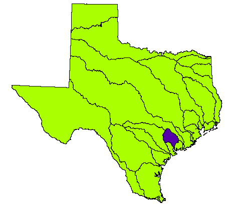
The following map shows the locations of the major basins in the state of Texas. The area of concern for this project is the Lavaca Basin in southeast Texas which is highlighted on the map.
Major Basins of Texas
Processing the DEM
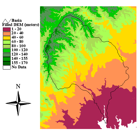
The DEM containing the Lavaca Basin was formed when four 3" quadrangles were merged. The DEM was then clipped to eliminate some of the excess grid surrounding the Lavaca Basin. The sinks in the grid were filled following clipping the DEM. The grid was resampled to produce a cell size of 100 meters throughout the basin and the sinks were filled again. To eliminate potential difficulties related to existence of the bay beyond the outlet of the Lavaca Basin, a query of the DEM was conducted for all values values greater than 0 using the Map Query feature in Spatial Analyst extension in Arcview. Under the Map Query feature, the expression ([lav100] > 0.asgrid) is entered. This creates a grid with all of the values that were equal to or less than zero changed to NODATA cells. This grid was than filled. The resulting DEM is shown in the following figure.
DEM of the Lavaca Basin
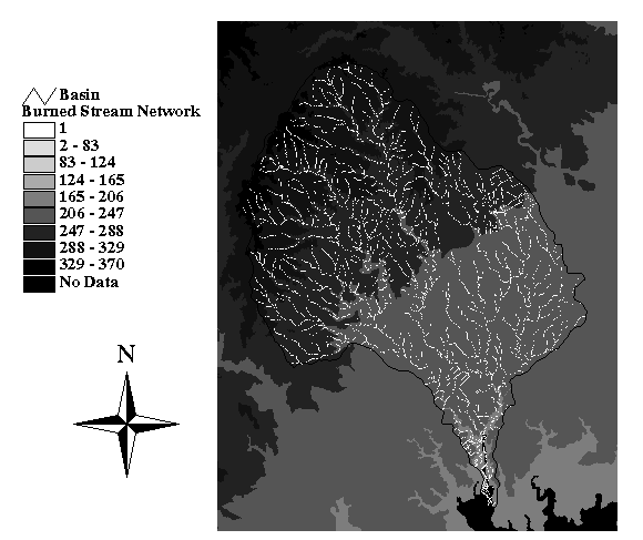
Burning in the Stream Network
The stream network used for this analysis is from the 1:100,000 Digital Line Graph (DLG) prepared by the United States Geological Survey (USGS). The method for burning in the stream network to the DEM is the following.
- Create a grid of the stream network with the Convert to Grid feature under Theme in a view of Arcview
- Divide the grid of the stream network by itself to create a grid with a value of 1 along the stream and NODATA everywhere else using the Map Calculator in the Spatial Analyst
- Again using the Map Calculator, add a value to the DEM grid (200 meters was used in this case)
- Run the BURNDEM script to merge the stream network with the DEM
- Fill the new DEM with the stream network and create the flowdirection grid for later use using the following GRID commands
Grid: fill burndem burnfil SINK # #
Grid: lavfdr = flowdirection (burnfil)
The result of this process is shown in this figure.
Burned in Streams in the Lavaca Basin
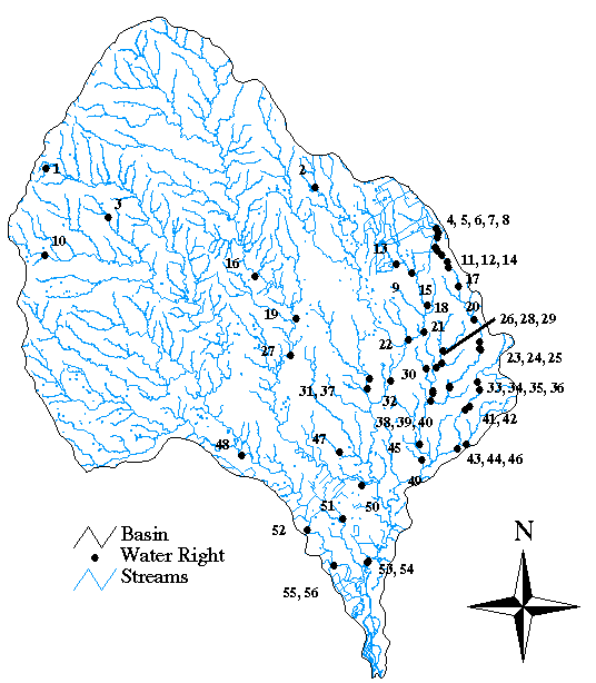
Creating the Point Coverage of the Water Rights in the Lavaca Basin
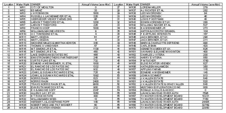
In the Lavaca Basin, there are 70 water rights at a total of 56 locations along the streams. Multiple water rights exist in some locations. The following table lists each of the water rights, the location numbers, the owners, and the annual volume in acre-feet.
Each water right was mapped according to its latitude and longitude. A text file wr.dat containing each of the 56 water right location numbers and its respective latitude and longitude was created. Using this file, a point coverage of the water rights locations was generated using the following commands.
Arc: generate wrpoint
Generate: input wr.dat
Generate: points
Generate: quit
Arc: build wrpoint points
Arc: addxy wrpoint
This attribute table of the point coverage was then linked with the master table for the water rights which contains additional information about the individual water rights at each location. The locations for these water rights are shown on the following figure.
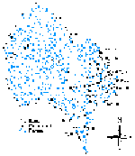 Click here for the Water Rights Locations
The point coverage of the water rights in the Lavaca Basin was converted to a grid with 100 meter cells with their annual values as the grid cell values. The annual withdrawal volumes of multiple water rights found at a single location were added together to give one value per location. Cells where no water rights were present were assigned the NODATA value. The conversion of the point coverage to a grid was accomplished using the Convert to Grid feature under Theme in Arcview. Although latitude and longtitude locations were used to create the point coverage, some of the grid cells representing the water rights did not coincide with grid cells along the stream although they were all within five grid cells distance. Examining a close-up view of each water right allowed the determination of the number of grid cells that particular water right needed to be moved to coincide with a grid cell along the stream. To move each of the water rights that required it, the table with all of the water rights locations and their respective coordinates was exported in .dbf format to be edited in a spreadsheet. The locations were edited, a new point coverage was created, and the coverage was converted to a grid.
Comparison of Point Coverage along Burned Stream Network to Streams Derived from Watershed Delineation
A second method for deriving the stream network is use the DEM to define drainage pathways according to elevations. A list of the commands used in GRID to find the stream network are as follows using a threshhold value of 500 cells.
Grid: lavfdr = flowdirection (fil100)
Grid: lavfacc = flowaccumulation (lavfdr)
Grid: str1 = con (lavfacc > 500, 1)
Grid: lnk1 = streamlink (str1, lavfdr)
Grid: acc1 = zonalmax (lnk1, lavfacc)
Grid: out1 = con (acc1 == lavfacc, lnk1)
Grid: shd1 = watershed (lavfdr, out1)
Grid: covshd1 = gridpoly (shd1)
A comparison of the point coverage with the two stream networks in the basin is provided in the following two figures.
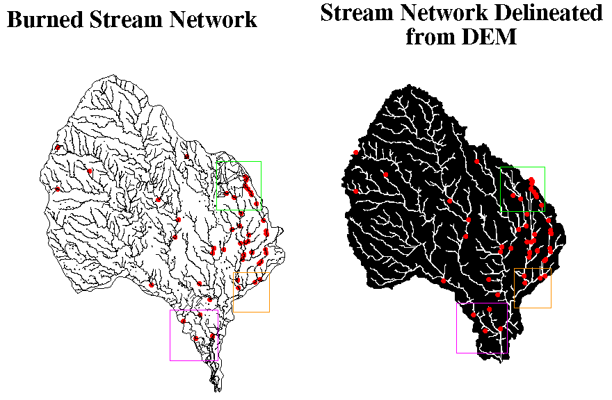
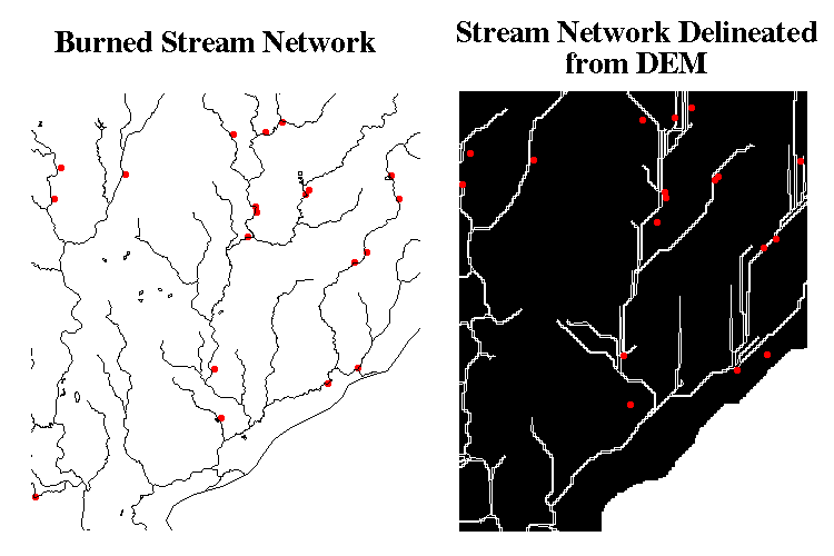
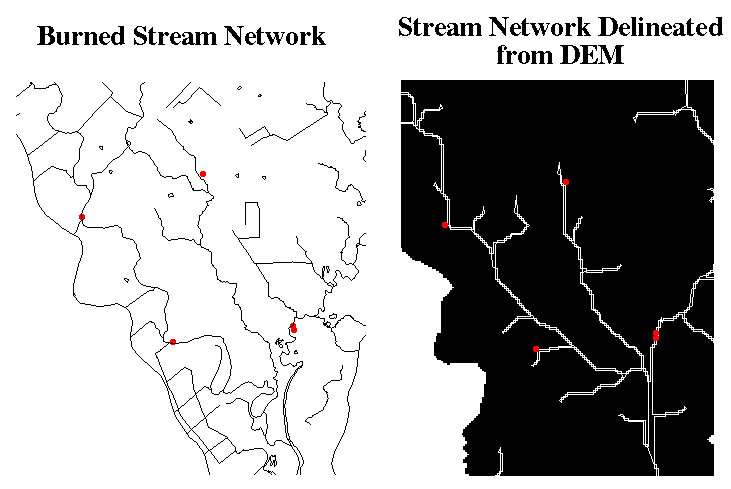
The areas encompassed in the three boxes are shown in the following six figures to show how close some of the individual points in the water rights are in relation to the two different stream networks. The figure on the left of each of the three pairs that follow shows the points along the burned stream network. Most of the points are exactly on top of this stream coverage. The figure on the right shows the point coverage on the stream network derived from the DEM. The first pair is the area in the green box, the second pair is the area in the orange box, and the third pair is the area in the pink box. In comparison with the burned streams network, there is a large discrepancy between many of the point locations and the stream network.

Creating Runoff Grids from Precipitation Data
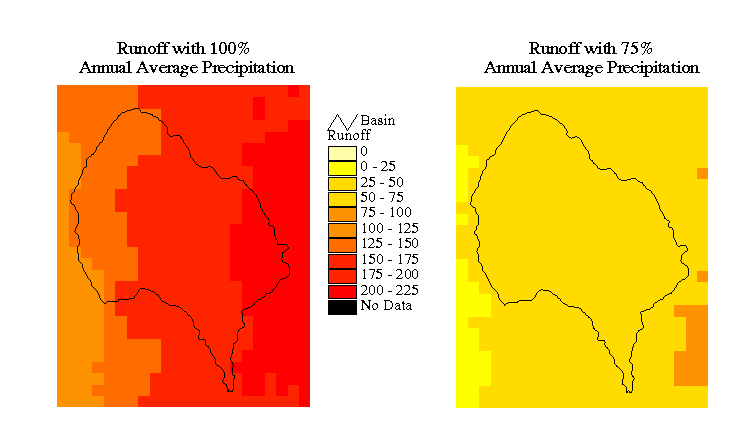
A grid of precipitation data with 500 meter cells for the state of Texas was used in Spatial Water Balance of Texas. The precipitation values in the grid are annual averages. The precipitation grid was obtained and clipped to the size of the DEM used in the analysis of the Lavaca Basin. The grid was then resampled to produce 100 meter cells for analysis. A rainfall/ runoff relationship function was developed for the state of Texas in the Spatial Water Balance of Texas report by Seann Reed. The runoff is determined by the following function.
Q = 0.00064 P exp (0.0061P) for P < Po
Q = 0.510 P - 339.1 for P > Po
where
Q = runoff (mm/yr)
P = precipitation (mm/yr)
Po = 801 mm/yr
Four runoff grids were created from the precipitation grid. The first grid was created for a rainfall of 100% of the annual average. The second, third, and fourth grids were created after multiplying the rainfall grid by a factor of 0.75, 0.50, and 0.25 using the Map Calculator. Each of the runoff grids was created using the ROGRID script.
Flow Accumulations of Runoff and Water Rights
Weighted flow accumulations were conducted using each of the four runoff grids and the grid of water rights. These were done using the following commands in GRID.
Grid: 100acc = flowaccumulation (lavfdr, r100pct)
Grid: 75acc = flowaccumulation (lavfdr, r75pct)
Grid: 50acc = flowaccumulation (lavfdr, r50pct)
Grid: 25acc = flowaccumulation (lavfdr, r25pct)
Grid: wracc = flowaccumulation (lavfdr, wrgrid)
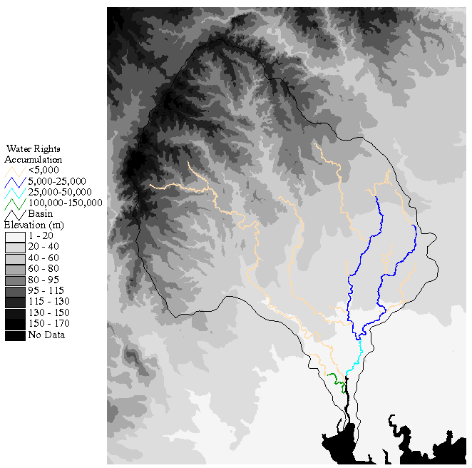
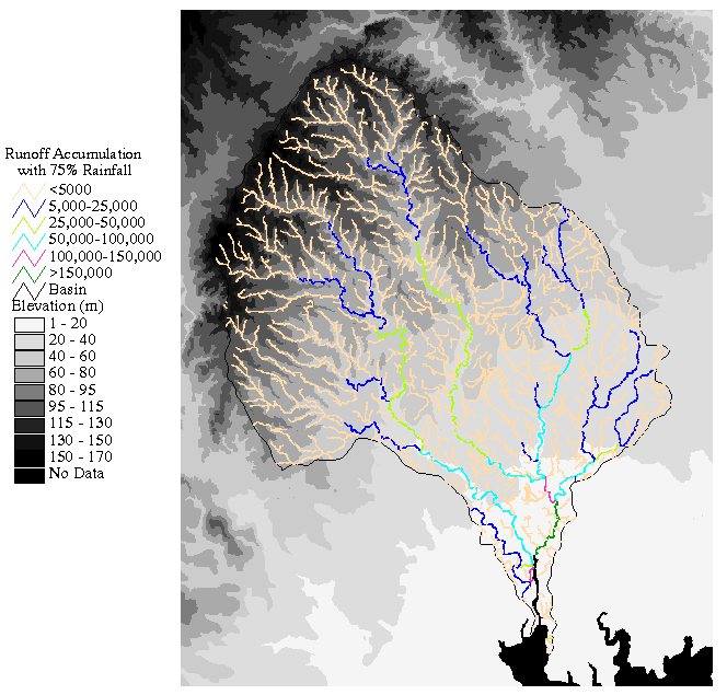
The following two graphics are maps of the flow accumulations. The first is a map of the water rights accumulation and the second is the map of the runoff accumulation for the 75% rainfall. The units for the accumulations on the maps are in acre-feet per year.
Water Rights Accumulation
Runoff Accumulation with 75% Rainfall
Subtraction of Water Rights Accumulation from Runoff Accumulation
Using the Map Calculator in Arcview, the grid of accumulated water rights was subtracted from each of the four grids of accumulated runoff. The equation entered into the Map Calculator for the runoff with 100% of the annual average is ([100acc]*0.008107-[wrgrid]). The factor of 0.008107 accounts for the conversion of the runoff grid which is in mm/yr to acre-ft/yr. The conversion is shown as follows.
(1mm/yr) * (100m*100m) * (0.00328ft/mm) * (0.000247acre/m2) = 0.008107 acre-ft/yr
Once each of these four grids was created, a query was performed using the Map Query feature under Analysis in Arcview. The query for the case with 100% rainfall was ([100minus] < 0.asgrid). This creates a grid of locations where the flow accumulation of the water rights exceeded the amount of accumulated runoff available. Although this produces a grid of the desired values, it is sometimes difficult to see on the view of the Lavaca Basin. For viewing purposes, this new grid was converted to a shapefile and then converted to arcs using the shapearc command in arc. Both the line color and weight can be adjusted in this format. This procedure was followed for the remaining three grids. The results are shown in the following four figures. The locations along the streams where shortages in supply are predicted for each of the rainfall conditions are indicated by the red arcs present on each of the maps.
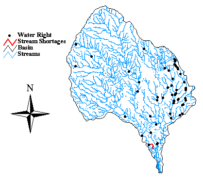
Potential Shortages with 100% Rainfall
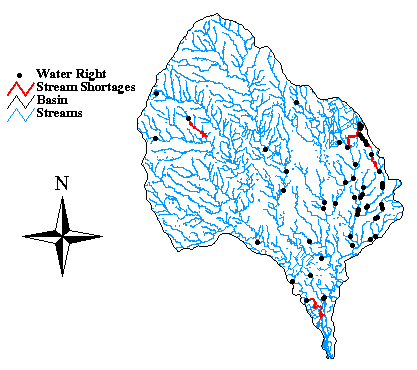
Potential Shortages with 75% Rainfall
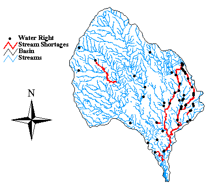
Potential Shortages with 50% Rainfall
Potential Shortages with 25% Rainfall
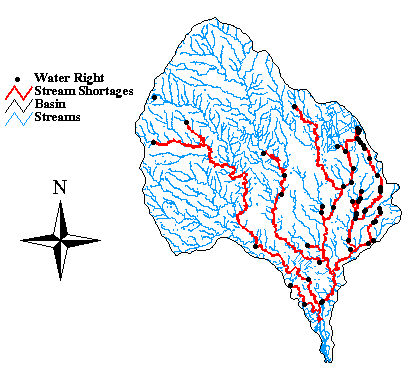 If the maximum amount of water is withdrawn that is allowable from the water rights, potential shortages in water supply are predicted for each of the four percentages of the average annual rainfall analyzed. For the 100% average annual rainfall case, there is a shortage in supply predicted for one section of the stream network which is associated with one water right. This identification of a single water right associated with a potential shortage is important because it shows this technology as a potential means of determining limits on allowable extraction volumes of water at any given location along a stream. The total length of the stream network where shortages are predicted increases with decreasing precipitation.
Conclusions
Some of the conclusions from this report are listed.
- In the Lavaca Basin, the point coverage of water rights generated from latitudes and longitudes matched the burned stream network better than the stream network derived from the DEM.
- If the maximum amount of water is withdrawn that is allowable from the water rights, potential shortages in water supply are predicted by this method for each of the four percentages of the average annual rainfall analyzed. For the 100% average annual rainfall case, there is a shortage in supply predicted for one section of the stream network which is associated with one water right. The total length of the stream network where shortages are predicted increases with decreasing precipitation.
- The process described in this report for assessing the potential shortages in water supply resulting from water rights and varying rainfalls can be used for other locations in Texas. There is also limitless potential for the extension of this process to produce other useful results relating to the water rights in Texas.
Click here for the Data Dictionary
 Click here for the Water Rights Locations