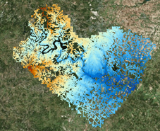
 Road
Elevation Model
Road
Elevation Model
1-Page Description RoadElevationModel1Pager.pdf
Video: https://youtu.be/CcjO0Mgj_10
Short Video: Road Elevation Model
Viewer: https://viewer.copc.io/
Sample Dataset for Viewer: road.copc.laz (1.9 GB) https://tinyurl.com/4f2b3nus
Sample Dataset for Analysis: travis_road_lidar.laz (1.9 GB) https://utexas.box.com/s/5dqn7kf9x2md2z32udxo354a0dk9d8a6
Direct Viewing on the Web: https://viewer.copc.io/?copc=https://txbridge-data.s3.amazonaws.com/road_elev_model/road.copc.laz
Road Elevation Model Data
By Maintenance Sections:
By Counties: https://web.corral.tacc.utexas.edu/nfiedata/road3d/austin_district/AustinCounties_H_epsg6343_V_epsg5703/
Tutorials
1-Page Summary: Road
Elevation Model Tutorials
Tutorial 1: Building a Road Elevation Model
of the Shoal Creek Watershed
Tutorial 2: Flood Inundation Map for Anderson Lane at Shoal Creek
Tutorial 3: Impact on Roads of a 100-Year
Flood in Shoal Creek