FOR HYDROLOGIC MODELING
The information on this page arose from my Master's work. The project goal was to develop GIS-based programs that could be used to integrate NEXRAD rainfall data and digital elevation models to extract rainfall-runoff modeling parameters. The research project was sponsored by the U.S. Army Corps of Engineers Hydrologic Engineering Center (HEC) in Davis, CA.
The National Weather Service's (NWS) Next Generation Weather Radar (NEXRAD)
radar program generates a product called StageIII which offers gridded
precipitation estimates spatially averaged over grid cells of approximately
16 square kilometers and temporally averaged over 1 hour. These data are
are becoming available for general use on the Internet -- for more information
see:
Nexrad
On-Line Data Access.
For an inventory of the data available for the Austin-San Antonio area
see:
Station KEWX
- Austin/San Antonio, Tx.
For online, real-time data for Oklahoma, see:
Arkansas-Red River Basin Forecast
Center
The National Weather Service has already developed a system for using NEXRAD data for streamflow forecasts, but the algorithms are embedded in customized hardware and software. A first step for other users is to properly position radar precipitation estimates relative to land surface features.
NEXRAD data are referenced to a spherical earth datum while data sets describing the land surface (i.e. digital elevation models (DEMs)) are most commonly referenced to an ellipsoidal earth datum. NEXRAD StageII and StageIII estimates are defined on the Hydrologic Rainfall Analysis Project (HRAP) grid which is defined in a projected plane relative to a spherical earth datum. A study of the equations required to transform HRAP cells into a commonly used ellipsoid-based map projection has been undertaken. Details about this HRAP projection and distortions involved with using this projection are described in a draft paper which is now available online. Although transformation and distortion issues related to HRAP are quite complicated, creating a reasonable representation of the HRAP grid in geographic coordinates is fairly simple and can be achieved with the programs described below.
Paper: A paper written by Seann Reed and David Maidment entitled "Coordinate Transformations for Using Nexrad Data in GIS-based Hydrologic Modeling" has been accepted for publication in the Journal of Hydrologic Engineering.
Master's Report:
A GIS Procedure for Merging NEXRAD Precipitation Data and Digital Elevation
Models to Determine Rainfall-Runoff Modeling Parameters Two simple programs are available that can be used to generate an Arc/Info
polygon coverage of HRAP cells for any user defined region of the country.
In Netscape, clicking on any of the filenames below will allow you to view
the text. You can also save these text files to your local disk by choosing:
"File", "Save As." GENHRAP.F : FORTRAN 77 source code that
writes a file of coordinate values used to create a polygon coverage of
NEXRAD cells in geographic coordinates given a user specified geographic
extent. This code has been compiled and executed using an F77 compiler
on a Sun UNIX system. Compatibility with other compilers is unknown. "Genhrap.f"
creates four output files: "hrap.xxx","geoc.xxx","hrap.xxx.dat",
and "inputgc.xxx." Only the files "hrap.xxx.dat" and
"inputgc.xxx" are needed as input to the program "genhrap.aml."
GENHRAP.AML : An Arc/Info script written
in Arc Macro Language (AML) that creates a polygon coverage of HRAP cells
in geographic coordinates given the output from genhrap.f, projects these
cells using a user specified projection file, and attaches the appropriate
HRAP-ID values to the projected coverage. "Genhrap.aml" uses
the file "inputgc.xxx" to generate a polygon coverage and "hrap.xxx.dat"
to add HRAP coordinates as attributes to this coverage. "Genhrap.aml"
produces a coverage of HRAP Cells in your chosen projection called "xxxgeoccprj."
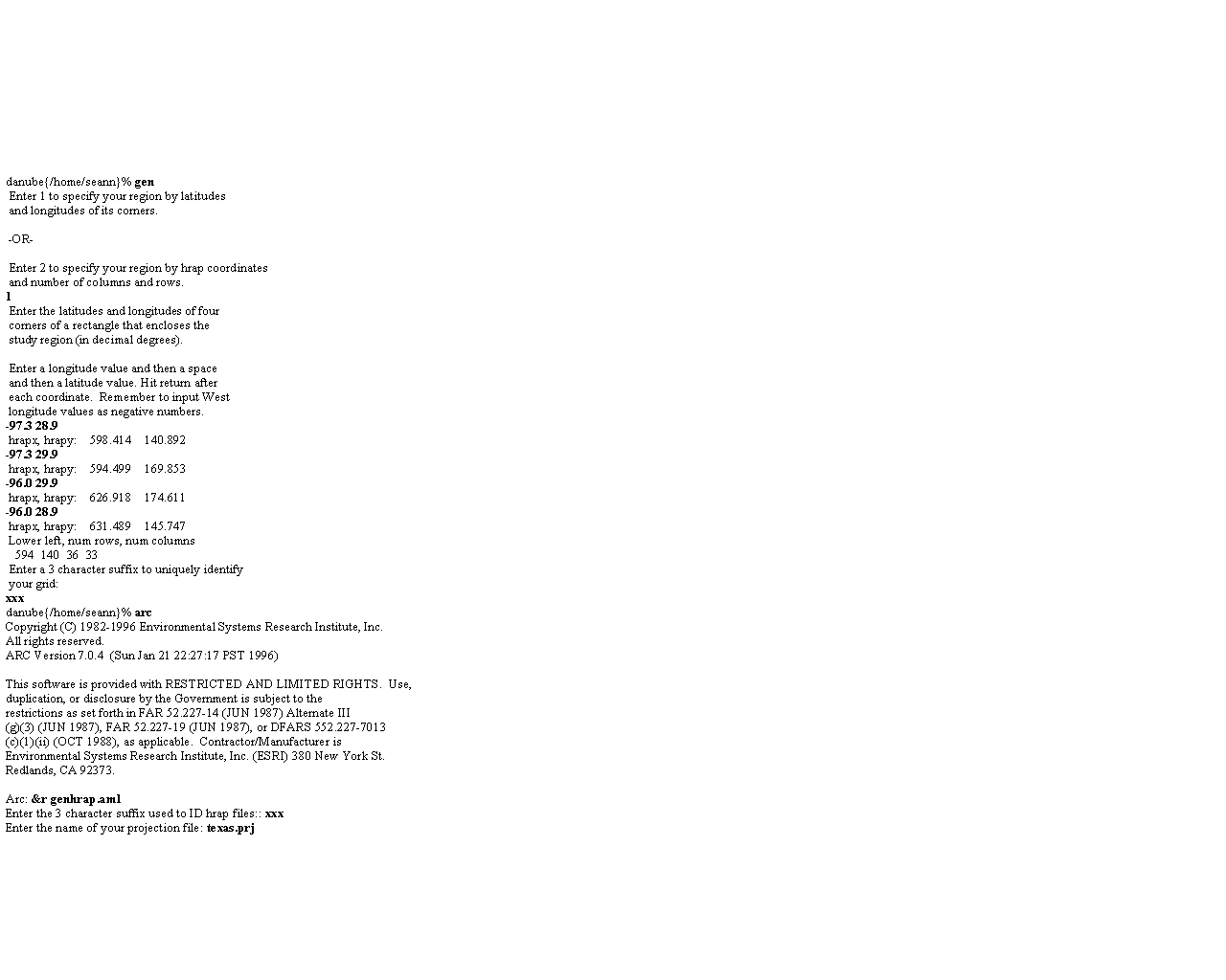
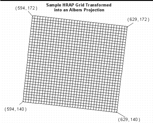
"xxx" refers to a user specified suffix. View a Sample Session Using these
Programs
Programs:
In this session, user input is presented in bold text. An image of the
results from this sample session may be viewed by clicking here.