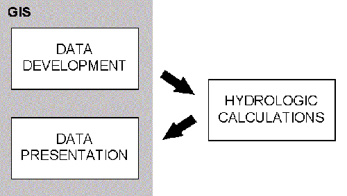
Figure 1. Current Hydrograph Calculation Procedure.
Runoff hydrographs provide important information for predicting the effect of land development on flooding and erosion. It is therefore of no surprise that the calculation of "before" and "after" hydrographs is standard practice in any kind of land development. Hydrograph calculation is a three step procedure consisting of (1) data development, (2) hydrologic calculations and (3) data presentation.
Traditionally all three steps were done manually without the aid of a computer. Data development involved the delineation of watershed boundaries from topographic and stream maps, and the determination of hydrologic surface properties, like runoff coefficients, by overlaying maps of land use, soil types and subarea boundaries. Similarly, hydrologic calculations and data presentation was done manually.
Today all three steps of the hydrograph calculation procedure are done utilizing computers. The first of the three steps to be computerized was the hydrologic calculation part through computer programs like TR-55 (SCS, 1986). After that the data development and data presentation steps were computerized through Geographic Information Systems (GIS). Delineation of watersheds and streams can be done from a Digital Elevation Model (DEM), a grid map of elevations (Maidment, 1996) and runoff coefficients can be calculated by overlaying maps of soils and land use, and linking the results to tables. Smith, for example, presents a complete hydrologic data development system which summarizes the data and writes it directly to the input file for a hydrologic calculation program (1995). GIS has also proven itself useful for presenting data. Figure 1 illustrates to current situation.
There is a need to move data back and forth among programs which is inefficient and introduces potential errors. It would be more efficient and safer to move hydrologic calculation part of the procedure into the GIS. Until recently, there were three main reasons, for the hydrologic calculations being done outside of the GIS. They were:
Today, these reasons are not valid anymore. First, the existing hydrologic calculation programs have to be reprogrammed anyhow, because the programs user interface is outdated. The current generation of computer users expects a program with a graphical user interface (GUI) that allows for manipulation of the data with simple point and click operations. This need has been acknowledged by the software producers. The Hydraulic Engineering Center (HEC), for example, is currently reprogramming it's line of software. Second, GIS systems are now offering more sophisticated programming environments suitable of hydrologic calculations. ArcView 2.1, for example, offers a powerful object oriented programming environment.
At this time serious consideration should be given to performing hydrologic calculations inside the GIS system and possibly combining the steps of data development, hydrologic calculations and data presentation. This project involved to programming of the Soil Conservation Service's Runoff Curve Number and Tabular Hydrograph methods (SCS, 1986) into a GIS.
This paper demonstrates how a hydrologic calculation procedure can be performed inside a GIS. Methods and input data requirements are discussed and a sample application is presented. Possible future work is also addressed followed by conclusions.
Two methods are used to calculate the hydrograph. The Runoff Curve Number method is used to determine the runoff and the Tabular Hydrograph method is used to calculate the composite hydrograph at the watershed outlet. Both methods are presented in Technical Release 55 (TR-55) published by the Soil Conservation Service (SCS, 1986). TR-55 presents simplified hydrologic calculation procedures applicable to small watersheds.
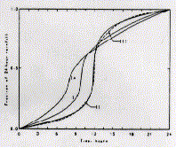
To calculate a hydrograph the TR-55 methodology begins with imposing a specific time distribution of rainfall uniformly in space over the watershed. There are four different time distributions for a 24-hour period (types I, IA, II and II, see Figure 2) The 24-hour time period was chosen because of the availability of data and the suitability of the time span to the applications of TR-55.
The rainfall is converted to runoff with the Runoff Curve Number method. A unit hydrograph is obtained from a table based on subarea and event specific variables. The unit hydrograph is then scaled by the runoff and the area to obtain the hydrograph using the Tabular Hydrograph method. The two methods are described in more detail below.
The system runs inside ArcView 2.1 (ESRI, 1995). It is designed to work in a PC and UNIX environment, but there have been problems when running the system in UNIX. It is written in Avenue, ArcView's object oriented programming interface. The numerical calculation procedure is identical to that outlined in TR-55 and the results obtained from this system are consistent with those obtained from the computer program distributed with TR-55. The program code is listed in Appendix A. The system is free and can be downloaded over the internet. Instructions on how to obtain the program are presented in with the sample application in section four.
It is important to keep in mind that TR-55 is a simplified procedure
with a number of important limitations to it. The limitations
are reproduced from TR-55 in Figure 3.
Limitations                          -Both the Graphical Peak Discharge
                                     and Tabular Hydrograph methods are
To save time, the procedures in      derived from TR-20 (SCS, 1983)
TR-55 are simplified by assumptions  output.  Their accuracy is
about some parameters.  These        comparable; they differ only in
simplifications, however, limit the  their products.  The use of Tc
use of the procedures and can        permits them to be used for any size
provide results that are less        watershed within the scope of the
accurate than more detailed          curves or tables.  The Graphical
methods.  The user should examine    method (chapter 4) is used only for
the sensitivity of the analysis      hydrologically homogeneous
being conducted to a variation of    watersheds because the procedure is
the peak discharge or hydrograph.    limited to a single watershed
To ensure that the degree of error   subarea.  The Tabular method
is tolerable, specific limitations   (chapter 5) can be used for a
are given in chapters 2 through 6.   heterogeneous watershed that is
Additional general constraints to    divided into a number of homogeneous
the use of TR-55 are as follows:     subwatersheds.  Hydrographs for the
                                     subwatersheds can be routed and
-The methods in this TR are based on added.
open and unconfined flow over land
or in channels.  For large events    -The approximate storage-routing
during which flow is divided         curves (chapter 6) should not be
between sewer and overland flow,     used if the adjustment for ponding
more information about hydraulics    (chapter 4) is used.  These storage
than is presented here is needed to  routing curves, like the peak
determine Tc.  After flow enters a   discharge and hydrograph procedures,
closed system, the discharge can be  are generalizations derived from
assumed constant until another flow  TR-20 routings.
is encountered at a junction or
another inlet.
Figure 3. Limitations of TR-55 (SCS, 1986).
The Runoff Curve Number Method.
The Runoff Curve Number method is used to estimate runoff. A detailed description of the method is presented in chapter 2 of TR-55. The method calculates runoff based on a curve number, CN and rainfall, P. See chapter 2 of TR-55 for details on how to calculate a composite CN.
The equations are
S = (1000/CN)-10
[Eq. 1-1]
Ia = 0.2*S
[Eq. 1-2]
Q = [(P-Ia)^2]/[(P-Ia)+S]
[Eq. 1-3]
where
S = potential maximum retention after runoff begins [in],
CN = runoff curve number,
Ia = initial abstraction [in],
P = rainfall [in], and
Q = runoff [in].
Solution - The runoff is calculated as follows:
S = (1000/75)-10 = 3.33
Ia = 0.2*3.33 = 0.67
Q = [(6.0-0.67)^2]/[(6.0-0.67)+3.33] = 3.28
The runoff is 3.28 inches.
The system obtains CN from the subarea attribute table. The system also offers a routine for entering attribute data. P is an event specific variable which is entered into a dialog box at the time of hydrograph calculation.
There are a number of limitations to the Runoff Curve Number Method. They are reproduced from TR-55 in Figure 4.
Limitations                          To use a relationship other than Ia
                                     = 0.2S, one must redevelop equation
-Curve numbers describe average      2-3, figure 2-1, table 2-1, and
conditions that are useful for       table 2-2 by using the original
design purposes.  If the rainfall    rainfall-runoff data to establish
event used is a historical storm,    new S or CN relationships for each
the modeling accuracy decreases.     cover and hydrologic soil group.

-Use the runoff curve number         -Runoff from snowmelt or rain on
equation with caution when           frozen ground cannot be estimated
recreating specific features of an   using these procedures.
actual storm.  The equation does
not contain an expression for time   -The CN procedure is less accurate
and, therefore, does not account     when runoff is less than 0.5 inch.
for rainfall duration or intensity.  As a check, use another procedure to
                                     determine runoff.
-The user should understand the
assumption reflected in the initial  -The SCS runoff procedures apply only
abstraction term (Ia) and should     to direct surface runoff: do not
ascertain that the assumption        overlook large sources of subsurface
applies to the situation.  Ia,       flow or high ground water levels
which consists of interception,      that contribute to runoff.  These
initial infiltration, surface        conditions are often related to HSG
depression storage,                  A soils and forest areas that have
evapotranspiration, and other        been assigned relatively low CN's in
factors, was generalized as 0.2S     table 2-2.  Good judgment and
based on data from agricultural      experience based on stream gage
watersheds (S is the potential       records are needed to adjust CN's as
maximum retention after runoff       conditions warrant.
begins).  This approximation can be
especially important in an urban     -When the weighted CN is less than
application because the combination  40, use another procedure to
of impervious areas with pervious    determine runoff.
areas can imply a significant
initial loss that may not take
place.  The opposite effect, a
greater initial loss, can occur if
the impervious areas have surface
depressions that store some runoff.
Figure 4. Limitations of the SCS Runoff Curve Number Method (SCS, 1986).
The Tabular Hydrograph Method.
The Tabular Hydrograph method is used to develop the composite hydrograph. First the method extracts a specific unit hydrograph from a table based on a number of subarea and rainfall variables. The variables found to have significant influence on the shape of the unit hydrograph are Rainfall Type, Ia/P, Tc and Tt. Where Tc is the time of concentration within the subarea and Tt is the travel time from the subarea outlet to the watershed outlet. The unit hydrographs for a number of ranges of these variables were developed using TR-20 (SCS, 1986), a more detailed hydrograph procedure.
In order extract the unit hydrograph from the table the program has to round the actual values of the variables to the tables values. Ia/P values are rounded to the nearest table value unless the user specifies to interpolate unit hydrograph values based on the Ia/P ratio. The actual Tc and Tt values are rounded to table values using the method described in TR-55. See Figure 5.
... round the actual values of Tc    2. Round Tc down and Tt up to
and Tt to values presented in the    nearest table value and sum: and
unit hydrograph table.  Perform      3. Round Tc up and Tt down to
this rounding so that the sum of     nearest table value and sum.
the selected table values is close
to the sum of the actual Tc and Tt.  From these three alternative,
 An acceptable procedure is to       choose the pair of rounded Tc and
select the results of one of the     Tt values whose sum is closest to
three rounding operations:           the sum of the actual Tc and Tt.
                                     If two rounding methods produce
1. Round Tc and Tt separately to     sums equally close to the actual
the nearest table value and sum;     sum, use the combination in which
                                     rounded Tc is closest to actual Tc.
Figure 5. Tc and Tt rounding procedure (SCS, 1986).
The unit hydrograph is scaled by the runoff, Q, calculated with the Runoff Curve Number method, and the area, Am, to obtain the hydrograph with the following equation:
q = qt * Am * Q
[Eq. 2-1]
where
q = hydrograph value at time t [cfs],
qt = unit hydrograph value at time t [cfs/(mi2 in)],
Am = subarea area [mi2], and
Q = runoff [in].
Solution - The runoff, Q, and Ia were calculated in the previous example to be 3.28 and 0.67 inches, respectively. Ia/P is rounded to the nearest table value as follows:
Tt and Tc are rounded to table values according to the procedure outlined in Figure 5. A comparison table is created as follows:
       Actual Values  Method 1   Method 2    Method 3
Tc     1.45           1.50       1.25        1.50
Tt     0.80           0.75       1.0         0.75
Sum    2.25           2.25       2.25        2.25
Since all the sums are equally close to the actual sum we will use the values which have the rounded Tc closest to the actual Tc. Tc and Tt are rounded to 1.50 and 0.75 hr respectively.
The unit hydrograph is obtained from the unit hydrograph table and scaled using Eq. 2-1.
The unit hydrograph and the resulting hydrograph are shown in the following table:
Time   11.0  11.3   11.6   11.9  12.0   12.1   12.2  12.3   12.4   12.5  12.6   12.7
qt     5     7      8      11    12     13     14    16     18     21    25     32
q      3     5      5      7     8      8      9     10     12     14    16     21

Time   12.8  13.0   13.2   13.4  13.6   13.8   14.0  14.3   14.6   15.0  15.5   16.0
qt     42    76     125    179   222    240    233   193    148    102   67     48
q      28    50     82     118   146    158    154   127    98     67    44     32

Time   16.5  17.0   17.5   18.0  19.0   20.0   22.0  26.0
qt     38    32     27     24    20     18     13    5
q      25    21     18     16    13     12     8     3
To get the composite hydrograph from multiple subareas the hydrographs from all the subareas are added at the watershed outlet.
The Rainfall Type is an event specific variable which is entered by the user in the event specific dialog box. The program calculates Ia/P from CN, which is found in the subarea attribute table, and P, which is entered in the event specific dialog box using Eq. 2-1 and Eq. 2-2. Tc and Am are also obtained from the subarea attribute table and Tt is obtained from the stream attribute table. The unit hydrographs are stored in tables which were created from tables distributed with the TR-55 computer program.
There are a number of limitations to the Tabular Hydrograph Method.
They are reproduced from TR-55 in Figure 6.
Limitations                          -Drainage areas of individual
                                     subareas differ by a factor of 5 or
The Tabular method is used to        more.
determine peak flows and
hydrographs within a watershed.      -The entire composite flood
However, its accuracy decreases as   hydrograph or entire runoff volume
the complexity of the watershed      is required for detailed flood
increases.  If you want to compare   routings.  The hydrograph based on
present and developed conditions of  extrapolation is only an
a watershed, use the same procedure  approximation of the entire
for estimating Tc for both           hydrograph.
conditions.
                                     -The time of peak discharge must be
Use the TR-20 computer program (SCS  more accurate than that obtained
1983) instead of the Tabular method  through the Tabular method.
if any of the following conditions
applies:                             The composite flood hydrograph
                                     should be compared with actual
-Tt is greater than 3 hours (largest stream gage data where possible.
Tt in exhibit 5).                    The instantaneous peak flow value
                                     from the composite flood hydrograph
-Tc is greater than 2 hours (largest can be compared with data from USGS
Tc in exhibit 5).                    curves of peak flow versus drainage
                                     area.
Figure 6. Limitations of the Tabular Hydrograph Method (SCS, 1986).
In order to calculate a hydrograph the system needs two themes (maps) with the necessary attribute data and some event specific information. Specific input data requirements are discussed below.
Stream Theme.
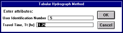
The stream theme is an arc, line or polyline theme representing the streams in the watershed. The lines have to be in the direction of flow, a new line has to start when crossing a subarea boundary and intersections with other lines and subarea boundaries have to be exact. The coverage has to contain the standard 'fnode#' and 'tnode#' (or 'fnode_' and 'tnode_') attributes defining connectivity. Further, the attribute table has to contain the 'tt' field specifying the travel time, Tt, through the stream. A simple point and click routine is provided for manipulating the Tt (see Figure 7). If the 'tt' field does not exist the program will add it to the attribute table automatically.
Subarea Theme.
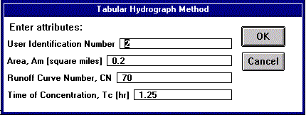
The subarea map is a polygon theme of the subareas in the watershed. The attribute table has to contain the 'am', 'cn' and 'tc' attributes. The 'am' specifies the area, Am, in square miles, the 'cn' attribute specifies the representative curve number, CN, and the 'tc' attribute specifies the time of concentration, Tc. A routine is provided for manipulating the attributes (see Figure 8). If the attribute fields do not exist the program will add them to the attribute table.
Hydrograph Calculation Point.
The hydrograph calculation point is the point where the hydrograph is to be calculated. The user communicates this point to the system by clicking on it subarea directly upstream of the point.
Event Specific Information.
Event specific information is information describing the rainfall event and options relating to the systems run. That information is entered at the time of hydrograph calculation in a pop up dialog box shown in Figure 9. The box comes up once the hydrograph calculation point has been defined.
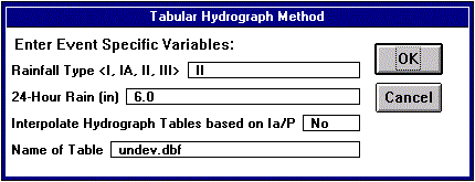
A developer proposes to put a subdivision, Fallswood, in subareas 5, 6 and 7 of a watershed in Dyer County, northwestern Tennessee (see Figure 10). Before approving the developer's proposal, the planning board wants to know how the development would affect the 25-year peak discharge at the downstream end of subarea 7. The rainfall distribution is type II, and the 24-hour rainfall is 6.0 inches. Compute the 'before' and 'after' hydrograph for the project. Use hydrologic properties as shown in Table 1. The data was adopted from Examples 5-1 and 5-2 from TR-55.

           UNDEVELOPED                         DEVELOPED

Subarea    Am [mi2]  CN    Tc [hr]   Tt [hr]  Am [mi2]   CN    Tc [hr]  Tt [hr]

1          0.30      65    1.50      --       0.30       65    1.50     --

2          0.20      70    1.25      --       0.20       70    1.25     --

3          0.10      75    0.50      0.50     0.10       75    0.50     0.50

4          0.25      70    0.75      --       0.25       70    0.75     --

5          0.20      75    1.50      1.25     0.20       85    1.50     1.00

6          0.40      70    1.50      --       0.40       75    1.00     --

7          0.20      75    1.25      0.75     0.20       90    0.75     0.50
Table 1. Sample Application Hydrologic Properties.
Step 1. Download the program and sample data.
The program can be downloaded via anonymous ftp from:
Address: ftp.crwr.utexas.edu
Login: anonymous
Password: your e-mail address
Directory: /pub/crwr/gishydro/tabhyd
Files: tabhyd.apr, typei.dbf, typeia.dbf, typeii.dbf,
typeiii.dbf, samstr.dbf, .shp, .shx, samsub.dbf, .shp, .shx
Step 2. Start the program.
Start up ArcView 2.1 open the "tabhyd.apr" project. You might encounter a number of path requests when first opening the program. ArcView will ask you for the location of the unit hydrograph tables. Simply supply the path when prompted. Save the project as "sam.apr" so that you will not modify "tabhyd.apr".
Step 3. Load the data.
Open a new View and add the samstr and samsub themes to it.
Step 4. Enter 'before' attributes.
Click on the 'A' button on the views toolbar. With this tool active you can edit attributes of the features on the map by clicking on them. The program notices if you click on a stream or a subarea and bring up the appropriate dialog box. Note that the program will add fields to the attribute tables if they are not already there. Add the attributes from Table 1 corresponding to undeveloped conditions. Note that only the streams flowing through subareas 3, 5 and 7 will be used for the hydrograph routing. The other streams will not be considered and you don't have to define attributes for them.
Step 5.Calculate the 'before' hydrograph
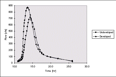
Once you have defined all the attributes you are ready to calculate the 'before' hydrograph. Click on the "H" button on the view's tool bar and then click on subarea 7. The program will ask you for event specific variables in a pop up box (See Figure 7). Enter the data from the introduction of the sample application. For this case do not interpolate hydrograph values based on the Ia/P ratio. Change the table name from it's default name to 'undev.dbf'. Once you are done entering the data click 'OK'. After the calculations are complete bring up the 'undev.dbf' table. The peak flow should be 720 cfs at 14.3 hours.
Step 6. Enter 'after' attributes.
Click on the 'A' button on the views toolbar and then change the attributes corresponding to the developed conditions as listed in Table 1.
Step 7. Calculate the 'after' hydrograph.
Similar to step 5, calculate the 'after' hydrograph and save the table as 'dev.dbf'. The peak discharge should be 872 cfs at 13.6 hours.
Figure 11 shows a comparison of the 'before' and 'after' hydrographs. As expected, the peak of the 'after' hydrograph occurs earlier and is higher.
The system presented in this paper performs the hydrologic calculation part of the hydrograph calculation procedure. Being able to perform this calculation inside a GIS is of considerable advantage, but an even greater advantage could be obtained if this step would be combined with the data development step. The result would be one complete hydrograph calculation system. For TR-55 this would include:
The data presentation side of the hydrograph calculation procedure can also be programmed into the system, by creating charts and layouts of the results. However, the benefit expected from automating this part would not be great. That is because ArcView already has very user friendly and powerful data presentation capabilities.
In general, performing other hydrologic calculation procedures, like TR-20 or HEC-1 could also be done inside a GIS. The calculation procedures for those methods are however much more complicated and would require a considerable larger effort to program.
The following conclusions can be drawn:
Environmental Systems Research Institute, Inc., ArcView 2.1, 1995.
Maidment, D. R., Using Grid to Perform Watershed Delineation(www.ce.utexas.edu/ prof/maidment/CE397/watershed/wshed.htm), CE397-GIS in Water Resources, The University of Texas at Austin, Spring 1996.
Smith, P., Hydrologic Data Development System, M.S. Thesis, The University of Texas at Austin, August 1995.
Soil Conservation Service, Computer Program for Project Formulation Hydrology, U.S. Dept. of Agriculture, Soil Conservation Service, Engineering Division, Technical Release 20, 1986.*
Hydraulic Engineering Center, HEC-1: Flood Hydrograph Package, U.S. Army Corps of Engineers, Hydraulic Engineering Center, 1990.
Soil Conservation Service, Urban Hydrology for Small Watersheds, U.S. Dept. of Agriculture, Soil Conservation Service, Engineering Division, Technical Release 55, June 1986.*
*For SCS publications contact:
National Technical Information Service
U.S. Department of Commerce
5285 Port Royal Road
Springfield, VA 22161
(703) 487-4650