These exercises are intended for self-learning in the application of GIS using Arcview to hydrologic issues in West Africa, in particular, in Morocco. They were prepared for a short course on GIS in Water Resources presented at the Direction Générale de l'Hydraulique in Rabat, Morocco, on 12-14 November 1996. The exercises were prepared by David Maidment and Seann Reed with help from Kris Martinez and Francisco Olivera. The exercises are presented in the English, French and Spanish languages. The French language translations were prepared by Christine Dartiguenave. Merci bien, Christine!! The Spanish language translations were prepared by Francisco Olivera. Muchas gracias, Francisco!!
The FAO/UNESCO Water Balance of Africa is an effort undertaken jointly by the Center for Research in Water Resources of the University of Texas at Austin, the UN Food and Agriculture Organization, and UNESCO, for the purpose of better assessment and planning of the water resources of Africa.
The work makes use of a gridded representation of the land surface terrain of the continent in the form of a 30" Digital Elevation Model of Africa, developed by the US Geological Survey in Sioux Falls, South Dakota, with the cooperation of the UN Environment Program.
The project has three main components:
The Niger River basin in West Africa is used as a case study region for the database and model development. Monthly soil water surplus is calculated using a simple Thornthwaite soil water balance model, although the evaporation computation has been modified to include a spatial database of net radiation obtained from the Earth Radiation Balance Experiment. These water surpluses are transferred onto subwatersheds of the Niger Basin and routed through its river system using the Muskingum method. The flow from the subwatershed to the river moves partly through the subsurface system and partly through the surface system, each delayed in time by a differing amount.
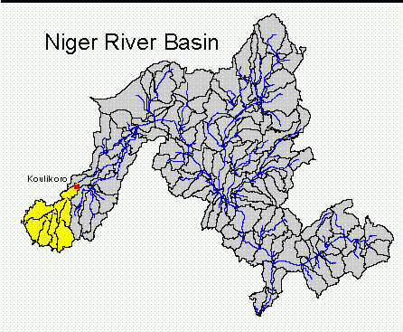
The results presented here are provisional and are subject to change as the project continues. The graphics attached depict the simulated and observed flow for the Niger river at Koulikoro, one of the principal gaging stations on the Niger river above its Inner Delta.
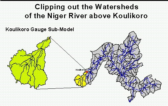
The results are obtained by clipping out a portion of the main basin model to form a Koulikoro submodel, including just those watersheds whose drainage passes through the gage at Koulikoro. Then the model parameters are optimized so that the discharge record there is fitted as well as possible.
The simulations carried out so far are for a 90 month period from July 1983 to December 1990. In the attached flow chart, the horizontal axis is the time in months from July 1983, the vertical axis is the Niger River discharge in cubic meters per second, the green lines are the calculated flows and the red lines are the measured flows at Koulikoro. The observed flow data were obtained from the Global Runoff Data Center in Koblenz, Germany.